aria.quick_link.navi aria.quick_link.skiptomaincontent aria.quick_link.footer
Garda Trentino Logo
Top

Bosco Caproni and Trenches of Vastrè

Arco

Category
Difficulty
Easy
Duration
2:00
Duration in hours
Distance
5.8
Distance in km
Status
open
WSEN
Suggested period
Jan
Feb
Mar
Apr
May
Jun
Jul
Aug
Sep
Oct
Nov
Dec

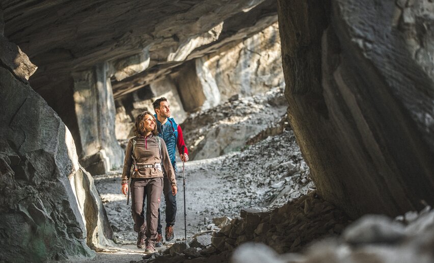
A nature walk which in just a few kilometres manages to give a fascinating insight into the historical events which left their mark on Garda Trentino

This trail tells the story of different episodes in Twentieth century history, winding through beautiful natural surroundings, the most northerly holly oak woodlands in Europe and many other species of vegetation. It leads you from the oolite quarries and the ruined houses of the miners who quarried the stone up to the trenches from the Great War.

Further information and useful links

For more information on routes, services (guides, mountain huts, shops etc.) and hiking friendly accommodation: Garda Trentino - +39 0464 554444

details
  • Scenic
  • Geological highlights
  • Insider tip
  • Round trip
  • Family-friendly
  • Cultural/historical interest
  • Flora
Route info
Easy
Route number
Distance
5,8 km
Duration
2 h 00 min
Altitude difference (+)
220 m
Altitude difference (-)
219 m
Physical effort
Scenary
Highest point
304 m
Lowest point
87 m
Suggestions

Today the oolite quarries are climbing walls where you can see top athletes challenging their skills on very demanding routes. If you can spare the time, stop off for a while and watch their slow progress on the rock.

Bosco Caproni gets its name from the family of Gianni Caproni, the famous aviation pioneer born in this area in 1886. Today this area is part of the River Sarca Reserve.

You might be interested in
Discover related tours
© Azienda per il Turismo Terme di Comano Dolomiti di Brenta, Garda Trentino
Intermediate
Comano
Val Marcia: The Witches Trail
Distance 7,0 km
Duration 3 h 00 min
Altitude difference (+) 875 m
Altitude difference (-) 81 m
Status
open
Between Tofino and Roda | © Alessandro de Guelmi, Garda Trentino
Difficult
Ledro, Tenno, Comano, Riva del Garda
Ledro Alps Trek Alpiedi - Leg 4: from Rifugio Pernici to Bivacco Campel
Distance 18,2 km
Duration 8 h 00 min
Altitude difference (+) 1.653 m
Altitude difference (-) 1.551 m
Status
open
Arca di Frà Porte | © APT Terme di Comano Dolomiti di Brenta, Garda Trentino
Intermediate
Comano
Arca di Fraporte
Distance 10,4 km
Duration 4 h 30 min
Altitude difference (+) 860 m
Altitude difference (-) 860 m
Status
open
The view from the Bastione | © Patrizia N. Matteotti (Archivio Garda Trentino) , Garda Trentino
Intermediate
Riva del Garda
Bastione and Santa Barbara, the lords of Riva del Garda
Distance 2,8 km
Duration 1 h 45 min
Altitude difference (+) 590 m
Altitude difference (-) 60 m
Status
open
View from the old "Maza" road | © Archivio Garda Trentino, Garda Trentino
Intermediate
Torbole sul Garda - Nago, Arco, Riva del Garda, Tenno
Garda Trek - Low Loop: in the heart of Garda Trentino
Distance 32,4 km
Duration 12 h 25 min
Altitude difference (+) 1.145 m
Altitude difference (-) 1.170 m
Status
open
Lake Ledro from Dromaè | © Alice Russolo, Garda Trentino
Intermediate
Riva del Garda, Ledro
Dromaé - Cima d'Oro
Distance 11,5 km
Duration 6 h 00 min
Altitude difference (+) 1.128 m
Altitude difference (-) 1.128 m
Status
partially open