Logo Garda
Top
Variante Santa Barbara Trail
Surroundings, Arco
Add to favourites
Category
Difficulty
Intermediate
Activity time
0:50
Duration in hours
Distance
6.1
Distance in km
Status
open
Suggested period
Jan
Feb
Mar
Apr
May
Jun
Jul
Aug
Sep
Oct
Nov
Dec

Pure entertainment in the Passo Santa Barbara area.

Signage: 759a. Variante Sta. Barbara - Trail

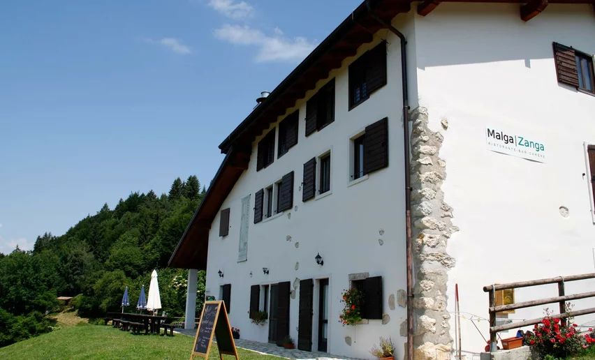
As an alternative to the wide paths of the 759. Monte Velo - Tour, branch off after 17.5 km and ride past Malga Zanga, taking the pleasant tracks to Santa Barbara. From there, a relatively easy trail leads through the forest back to the original route.


Further information and useful links

For more information on routes, bike services (rentals, workshops, shops) and cycling friendly accommodation: Garda Trentino - +39 0464 554444


Route info
Intermediate
Route number
759a
Distance
6,1 km
Activity time
50 min
Altitude difference (+)
180 m
Altitude difference (-)
330 m
Technical skills
Physical effort
Scenary
Highest point
1.212 m
Lowest point
909 m
Suggestions

At Malga Zanga you can have a drink or something to eat along the way.

Safety guidelines

ITRS - International Trail Rating System

The ITRS is an objective way to assess trails and routes from a biker’s perspective, evaluating four aspects:

  • Technical Difficulty: riding skill level needed
  • Endurance: combined effect of length, uphill and downhill
  • Wilderness: amount of planning required based on mobile phone reception, rescue options, water supply and wildlife
  • Exposure: consequences of a fall

Discover more about the ITRS system and check the classification of this tour in the photo gallery.


Safety Tips

  1. Always wear your helmet.
  2. Plan your ride.
  3. You share the trail with other users. Yield right of way to hikers.
  4. Let your speed be determined by your experience.
  5. Ride slowly on crowded trails, overtake with politeness and respect.
  6. Cycle only on authorized and open trails.
  7. Avoid muddy trails in order not to damage them further.
  8. Respect public and private property.
  9. Always be self-sufficient.
  10. Do not cycle solo in remote areas.

This information is subject to inevitable variations, so none of these indications are absolute. It is not entirely possible to avoid giving inexact or imprecise information, given how quickly environmental and weather conditions can change. For this reason, we decline any responsibility for changes which the user may encounter. In any case, it is advisable to check environment and weather conditions before setting out.

Punto di partenza
Malga Zanga
Directions

The route starts in Arco: more specifically, at the cycle path near to Caneve car park. Following the directions, head towards the centre of the town. N.B. there is no route signage in the town centre. However, once you reach the clearly identifiable church, cross Piazza 3 Novembre and, keeping to the right, take Via Segantini. When you reach the stop sign - near the bridge, cross the road and take the cycle path which runs along the River Sarca. Following the river, cross it and continue northwards, encountering a bicigrill. Turn right here to go through the small village of Moletta, and when you reach the intersection, regulated by a traffic light, cross the main road to take a secondary one proceeding to the right: in the direction of San Martino. Before reaching the village itself - at the first junction, keep left to follow the road, rising ahead of you, through the olive trees.

Continuing to follow the route signage, you will be guided past a cliff known as Policromuro: a very popular spot for climbers. You will also pass an archaeological site with rock carvings, to eventually reach the chestnut grove of Pianaura. Here continue right in the direction of Troiana and, subsequently, Carobbi. Once in this area, before continuing straight on, at the junction for Braila there is the chance to refresh your water supply. Returning to follow the signs: after a short stretch of descent through woodland, start to climb towards Passo Due Sassi. On clear days, this particular stretch of route, taking you up to Malga Zanga, offers stunning scenery. However, it would be wise to reserve some of your energy, as once past the Malga (hut), a final effort is required to conquer the ultimate part of the climb. Upon reaching the asphalt road, follow the road to the right, leading you to Passo Santa Barbara.

At the stop sign, where you will also find a fountain - Keep right. Continue along the road for approximately one hundred metres. Then, paying attention to the route signage, leave the main road keeping left, to quickly meet a gravel track. It’s at this point of the route, descending toward Malga Fiavei, that the terrain is at its most unstable. However, once past the Malga, you will notice the surface improves again.

Shortly after passing a bar (to stop traffic access), you will find yourself in the final part of the descent on asphalt. Reaching the stop sign at Bolognano, keep left - continuing to descend until you reach the church in the centre of the village. Keep right here, to Via Asilo: meeting the necessary turn a few metres after passing the church. Near the road which curves round to the right, keep to the left to continue straight on a gravel road. At the next junction keep left, then right. Continue straight until you reach Viale Rovereto - almost there! You just have to keep left here for a few dozen meters, finally taking the path on your right, leading you back to the route starting point.

public transportation

The main towns in Garda Trentino - Riva del Garda, Arco, Torbole sul Garda, Nago – are connected by several urban and intercity bus lines which will take you to the starting point of tours or in the immediate surroundings.

You can also get to Riva del Garda and Torbole sul Garda by the public ferry service.

Up-to-date information on timetables and routes.


How to get there
Where to park

Parking in Caneve (5 minutes walk to the town centre, starting point of the 759. Monte Velo - Tour).

Paid parking: Foro Boario, near the bridge (Via Caproni Maini) or the post office (Via Monache).

Riding your bike requires specific clothing and equipment, even for relatively short and easy trips. It is always better to be prepared… e.g. for bad weather or a sudden drop in your energy levels. The unexpected things are part of the fun!

Remember to thoroughly evaluate the type of route you plan on doing, the locations you intend to cross and the current season. Has it been raining? Attention: The paths may be slippery and require more caution.

What do I need to bring on my bike tour?

  • An adequate water supply according to your needs (considering temperature, possibility of refuelling and duration of the route)
  • Plenty of snacks (for example, dried fruit or energy bars)
  • Waterproof / Windproof jacket
  • A spare top / spare socks (Descending in a sweaty garment, will make you cold).
  • Suncream
  • Sunglasses
  • Bike gloves/mitts
  • Map or GPS device
  • Bike lights: best placed on your helmet or handlebars. (It is always best to be prepared)
  • Bike repair kit for punctures and mechanical breakdowns
  • First aid kit
  • Emergency whistle

It is always advised to let someone know where you plan to go and how long you expect to be.

Emergency telephone number 112.

Arco
E-Bike Stop Malga Zanga - Monte Velo
bike stop
Arco
E-Bike Stop Info Point Arco
bike stop
Arco
E-Bike Stop Parking Caneve - Arco
bike stop
Arco
E-Bike Stop Parking Carmellini - Arco
bike stop
Arco
E-Bike Stop Bicigrill Moletta - Arco
bike stop
You might be interested in
Discover related tours
Valle dei Laghi, Dro & Drena
Distance 8,8 km
Activity time 54 min
Altitude difference (+) 64 m
Altitude difference (-) 58 m
Status
open
Tenno
Distance 10,4 km
Activity time 1 h 20 min
Altitude difference (+) 280 m
Altitude difference (-) 280 m
Status
open
Riva del Garda
Distance 6,2 km
Activity time 50 min
Altitude difference (+) 240 m
Altitude difference (-) 240 m
Status
open
Torbole sul Garda - Nago, Arco, Riva del Garda
Distance 8,5 km
Activity time 50 min
Altitude difference (+) 20 m
Altitude difference (-) 20 m
Status
open
Arco, Dro & Drena
Distance 10,7 km
Activity time 1 h 25 min
Altitude difference (+) 280 m
Altitude difference (-) 280 m
Status
open
Arco
Distance 7,9 km
Activity time 50 min
Altitude difference (+) 97 m
Altitude difference (-) 98 m
Status
open