aria.quick_link.navi aria.quick_link.skiptomaincontent aria.quick_link.footer
Garda Trentino Logo
Top

Monte Stivo

Val di Gresta, Arco

Category
Difficulty
Intermediate
Duration
4:00
Duration in hours
Distance
9.7
Distance in km
Status
open
WSEN
Suggested period
Jan
Feb
Mar
Apr
May
Jun
Jul
Aug
Sep
Oct
Nov
Dec

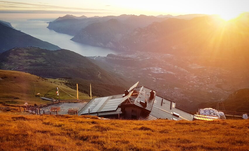
Monte Stivo dominates Garda Trentino, and from its summit you have one of the most spectacular views over Lake Garda and the surrounding valleys.

The trail soon takes you above the woods and onto the wide open pastures which cover the summit of Monte Stivo and are clearly visible from the Basso Sarca. You are likely to come across cows and horses grazing on the pastures. Monte Stivo is an imposing presence in Basso Sarca, its bulk towering above the "Busa" (the flat lands between Riva del Garda, Arco and Torbole).

Proverbs in local dialect bear witness to the importance of this mountain in the life of the community, with expressions like "When Stivo has its hat on, either it's going to rain or the sun's coming out soon” (Quando el Stif el g'ha el capel o che'l piove o che'l fa bel".) The “hat” is the crown of cloud which covers the peak of the mountain and is a sign of variable weather.

There is an observation/viewing point near the mountain hut which identifies all the surrounding peaks from Monte Baldo to the south, the Ledro Alps to the southwest, the Adamello glaciers, Carè Alto and Presanella to the northwest, the Brenta Dolomites to the north, the lesser Dolomites, Lagorai and Pasubio chain to the east. 

Further information and useful links

For more information on routes, services (guides, mountain huts, shops etc.) and hiking friendly accommodation: Garda Trentino - +39 0464 554444


Route info
Intermediate
Route number
Distance
9,7 km
Duration
4 h 00 min
Altitude difference (+)
850 m
Altitude difference (-)
856 m
Physical effort
Scenary
Highest point
2.057 m
Lowest point
1.227 m
Suggestions

On clear days, in the space of just 70 km, you can see an incredible difference in elevation which ranges across all the landscapes of Trentino: from the 64 metres above sea level at Lake Garda to the summit of Ortles at 3905 metres!

You might be interested in
Discover related tours
© Azienda per il Turismo Terme di Comano Dolomiti di Brenta, Garda Trentino
Intermediate
Comano
Val Marcia: The Witches Trail
Distance 7,0 km
Duration 3 h 00 min
Altitude difference (+) 875 m
Altitude difference (-) 81 m
Status
open
© Fototeca Trentino Sviluppo foto di A. Russolo, Garda Trentino
Intermediate
Valle dei Laghi, Comano
Passo della Morte: a path through nature and legend
Distance 7,7 km
Duration 3 h 30 min
Altitude difference (+) 299 m
Altitude difference (-) 547 m
Status
open
Eremo di San Giacomo - Arco | © A. Galvagni ©APT Garda Trentino , Garda Trentino
Intermediate
Arco
10. To the Hermitage Eremo di San Giacomo
Distance 4,2 km
Duration 2 h 15 min
Altitude difference (+) 615 m
Altitude difference (-) 8 m
Status
open
© Staff Outdoor Garda Trentino AC, Garda Trentino
Intermediate
Ledro
Walking tour of the mountain huts of Val di Concei
Distance 14,6 km
Duration 7 h 00 min
Altitude difference (+) 1.035 m
Altitude difference (-) 1.035 m
Status
open
Giro delle cime | © Stefania Oradini, Garda Trentino
Difficult
Tenno, Ledro, Comano, Riva del Garda
Summit Tour
Distance 25,8 km
Duration 11 h 00 min
Altitude difference (+) 2.488 m
Altitude difference (-) 2.488 m
Status
open
© Staff Outdoor Garda Trentino AC, Garda Trentino
Difficult
Ledro
Tour of the malghe of Molina
Distance 13,8 km
Duration 6 h 00 min
Altitude difference (+) 1.286 m
Altitude difference (-) 1.288 m
Status
open