Directions
The route departs from Riva del Garda, next to the Garda Trentino Tourist office.
So, from the tourist office head north to the roundabout, keeping left to take the cycle path of via Dante Alighieri. Once you reach Viale Roma, turn right and follow the road to take the next turn left onto Viale Pilati. At the junction turn right onto viale Giovanni Prati and continue straight onto Via Ardaro.
Here the climbing starts gently, but prepare yourself for the very different gradients ahead. After crossing the village of San Giacomo, a little before reaching the crossroads you will see the signage for MTB route 734. Follow it to cross the road where you must take the steep slope on your right which runs along the Albola stream.
The slope reaches 20% here and at the first fork, led by the signage, keep right where you can catch your breath for a few metres. Follow the narrow dirt road which will join with the provincial road toward Lake Tenno. At one of its hairpin bends, keep to the left taking a disused dirt track. The steepest stretch of climb is behind you at this point, but the ascents are still challenging. The alternative is to follow the normal/main road up to Pranzo, as do many road cyclists.
If you have the strength to stay on the dirt road, continue as indicated until you meet the asphalt road again, follow this for a few hundred meters, up to the next bend at Deva. Following the curve of the road, spot the sign leading you sharp right, continuing to climb again a dirt/gravel section eventually returning to the main road leading to Pranzo.
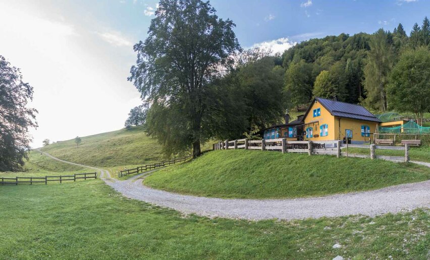
After passing through the narrow passageway regulated by a traffic light, follow the signs left to leave the provincial road for Lake Tenno and continue through the famous chestnut groves of the area. Back on the normal road there is a short stretch through a tunnel to reach Campi. From here it is easy to follow the signs to reach the Capanna Grassi refuge: the half way point of the route. The Refuge is unmissable stop for the Trentino regulars and a great opportunity to take a break and get some water. Otherwise you can shorten the tour and return to Riva (734a. Shortcupt Campi).
With or without a break, it’s now time to cross the torrent and prepare for the descent, which has in store a wonderful surprise: the first trail designed from scratch and entirely built by the Garda Rangers to create a tailor-made experience for bikers. The trail is suitable for all experience levels thanks to a regular surface and a width of 1,20 m, but there are lots of curves to ensure a fun experience as well! Near Parisi, the trail meets the concrete road.
All going well, you will pass by the characteristic San Rocco church following the path until the entrance of the Pinza on your right. From here the terrain returns to a more forgiving gravel kind. Take the time to enjoy the panorama, but please check your speed: even though the path is quite large, some sections are a little more dangerous. By the last section, on cement your brakes will be very hot. Finishing the descent you are practically at the entrance to the centre of Riva del Garda, your starting point.

, Garda Trentino")
, Garda Trentino")
, Garda Trentino")
, Garda Trentino")
, Garda Trentino")
, Garda Trentino")
, Garda Trentino")
, Garda Trentino")
, Garda Trentino")
, Garda Trentino")
, Garda Trentino")
, Garda Trentino")
, Garda Trentino")


, Garda Trentino")
, Garda Trentino")

, Garda Trentino")


