aria.quick_link.navi aria.quick_link.skiptomaincontent aria.quick_link.footer
Garda Trentino Logo
Top

GardaTrek - Top Loop 2: descent to Lake Tenno

Riva del Garda, Tenno

Category
Difficulty
Intermediate
Duration
5:00
Duration in hours
Distance
11.6
Distance in km
Status
closed
Suggested period
Jan
Feb
Mar
Apr
May
Jun
Jul
Aug
Sep
Oct
Nov
Dec

This stage goes from a hut to the next, from Nino Pernici to San Pietro, touching the verdant shores of lake Tenno and the evocative medieval village of Canale di Tenno. 

This stretch of the route is mostly downhill: it winds by the bottom part of the rocky rampart of Monte Tofino to reach Tenno's valley floor, a viewpoint onto the Alto Garda, well known for its medieval hamlets. It rises on the hillside of Monte Misone as up as San Pietro'mountain hut, a breathtaking observation post. 

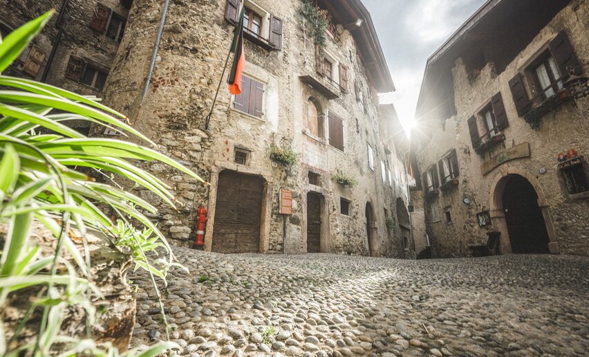
Less challenging than the previous one, this lengthily excursion still needs great effort nonetheless with great rewards. In fact, along the trail it is possible to admire the stunning intense shade of lake Tenno and visit the medieval village of Canale di Tenno, recognized from the association "Borghi più belli d'Italia" as one of the most beautiful villages in Italy. Countless are the places to freshen up if tired.

Leaving Canale in about one hour following an old mule track trough woods and chestnut grove, you reach the San Pietromoutain hut, the last stop and a natural scenic place with a magnificent overview of lake Garda.

Attention: check the condition of the trail with the manager of the mountain hut Rifugio Nino Pernici. Otherwise use the alternative route.

Further information and useful links
You’ve picked the perfect trail – now make sure you’re ready to enjoy it to the fullest. Local hiking specialists are here to help: guides, shops and experts with the tips and support you need for every step of the way.
Route info
Intermediate
Route number
Distance
11,6 km
Duration
5 h 00 min
Altitude difference (+)
678 m
Altitude difference (-)
1.305 m
Physical effort
Scenary
Highest point
1.715 m
Lowest point
575 m
Suggestions

In summer you should stop off at Lake Tenno. Take time out for a refreshing swim in the famous turquoise waters of the lake! 

San Pietro hut is easily accessible and one of the most popular destinations with visitors and locals alike. The hut was built on the foundations of the ancient hermitage which stood beside the little medieval chapel which is still standing today. There is a spectacular view from the terrace over Northern Garda.

You might be interested in
Discover related tours
View from Monte Altissimo | © Archivio Garda Trentino (ph. Watchsome), Garda Trentino
Difficult
Surroundings, Torbole sul Garda - Nago
GardaTrek - Top Loop 6: In the Garden of Europe
Distance 11,3 km
Duration 7 h 00 min
Altitude difference (+) 1.839 m
Altitude difference (-) 0 m
Status
partially open
Lake Toblino | © Armin Huber, Garda Trentino
Difficult
Valle dei Laghi, Comano
Cammino San Vili - low itinerary
Distance 107,6 km
Duration 35 h 00 min
Altitude difference (+) 3.228 m
Altitude difference (-) 4.553 m
Status
open
San Lorenzo Church - Tenno | © Archivio Garda Trentino (ph. Watchsome), Garda Trentino
Intermediate
Tenno, Arco, Riva del Garda
Sentiero Frassati - Leg 1
Distance 6,5 km
Duration 3 h 20 min
Altitude difference (+) 886 m
Altitude difference (-) 0 m
Status
open
View on lake Garda and Garda Trentino from the top of Monte Biaina | © G.P. Calzà, North Lake Garda Trentino
Difficult
Dro & Drena, Arco, Tenno
GardaTrek - Top Loop 3: a long descent to the River Sarca
Distance 20,3 km
Duration 7 h 55 min
Altitude difference (+) 1.000 m
Altitude difference (-) 2.000 m
Status
open
View on lake Garda from the trail | © Archivio APT Garda Trentino (ph. Calzà) , Garda Trentino
Difficult
Dro & Drena, Torbole sul Garda - Nago, Surroundings, Arco, Ledro, Riva del Garda, Tenno
Garda Trek - Top Loop: The crown of Garda Trentino
Distance 93,3 km
Duration 47 h 00 min
Altitude difference (+) 7.266 m
Altitude difference (-) 5.601 m
Status
partially open
View over Castel Stenico from BoscoArteStenico | © Archivio Garda Trentino (ph. M. Corradi), North Lake Garda Trentino
Difficult
Valle dei Laghi, Comano
Cammino di San Vili - High itinerary
Distance 92,7 km
Duration 40 h 00 min
Altitude difference (+) 4.259 m
Altitude difference (-) 5.596 m
Status
open