Logo Garda
Top

Malga Movlina and Rifugio XII Apostoli

Comano
Category
Difficulty
Intermediate
Duration
5:30
Duration in hours
Distance
11.4
Distance in km
Status
open
WSEN
Suggested period
Jan
Feb
Mar
Apr
May
Jun
Jul
Aug
Sep
Oct
Nov
Dec

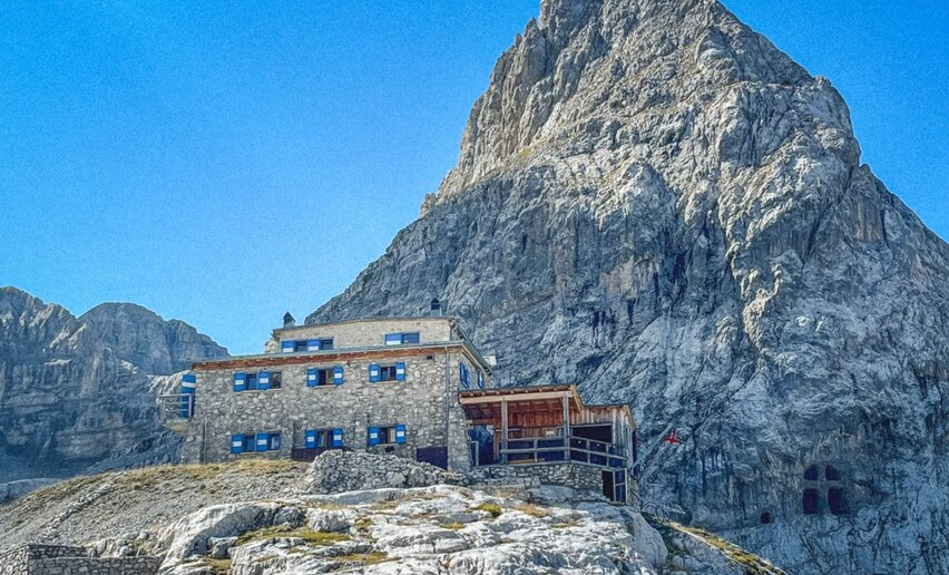
This excursion leads to the heart of Parco Naturale Adamello Brenta and offers breath-taking views of the Dolomites and the Adamello, passing through the spectacular Val Algone to reach Rifugio XII Apostoli (2.847 m).

Itinerary: Malga Movlina, Passo del Groto, Passo Bregn dal’Ors, Piani Nardis, Scalasanta, Rifugio XII Apostoli, Malga Movlina.

Further information and useful links

For more information on routes, services (guides, mountain huts, shops etc.) and hiking friendly accommodation: Garda Trentino - +39 0464 554444


Route info
Intermediate
Route number
Distance
11,4 km
Duration
5 h 30 min
Altitude difference (+)
932 m
Altitude difference (-)
932 m
Technical skills
Physical effort
Scenary
Highest point
2.579 m
Lowest point
1.754 m
Suggestions

Challenging at the start of Val Algone – Rifugio XII Apostoli Malga Movlina The Brenta Dolomites peaks.

Safety guidelines

Safety Tips

  1. Choose itineraries that suit your physical and technical abilities. Collect information about the area you are visiting and the trail’s conditions and get a detailed trekking map.
  2. Wear clothes and take equipment that suit the difficulty and length of your tour. Keep emergency gear in your rucksack, including first aid supplies.
  3. Do not go walking alone in the mountains. In any case, tell someone where you are going and report back on returning.
  4. Look at the weather forecast before setting off and always keep an eye on the weather.
  5. In case of doubt, go back. It is better to give up than risk bad weather or face difficulties beyond your strength, ability and equipment.
  6. Do not leave marked paths and do not take shortcuts.
  7. All described walks are in a natural environment and therefore their use is at your own risk.

This information is subject to inevitable variations, so none of these indications are absolute. It is not entirely possible to avoid giving inexact or imprecise information, given how quickly environmental and weather conditions can change. For this reason, we decline any responsibility for changes which the user may encounter. In any case, it is advisable to check environment and weather conditions before setting out.

Punto di partenza
Malga Movlina
Directions

From Stenico drive along the regional road towards Ragoli until you reach the junction for Val d’Algone. After about 7km along this paved road, you will reach Rifugio Ghedina (1120m), where you will find the ruins of a glass factory dating back to the last century. Here, the valley opens onto the fields revealing views of the imposing Vallon range (2968m), a paradise for alpine climbers and keen naturalists, who can withstand the challenge of a treacherous path and arduous sections. Continue through the fields passing, here and there, some mountain cabins, until you reach the Brenta Hotel: from here the road continues unpaved and the access is restricted to 50 vehicles per day via an automatic paying machine system (€ 6,00). After a series of bends, you will reach the southern end of the pastures around Malga Movlina where you can leave your car. The farmstead, in short distance, is a fantastic lookout point from where to gaze at the Presanella and the Brenta range. Continue along the SAT 354 that leads to Passo del Groto (1847m) and further ahead to Passo Bregn dal’ Ors (1836m) affording stunning views of Valdagola and its beautiful lake (30 minutes). From Bregn dal’ Ors, walk along the SAT 307 path descending to Pian di Nardis (1822m). Here, start climbing the “Scala Santa”, a set of rocky steps with a fixed steel rope as support, which leads to a steep gravelly slope. After climbing over another rocky outcrop, you will reach Rifugio XII Apostoli (2487m) in about 2 ½ hours. Near the mountain hut, there's a well-known chapel carved into the rock wall, dedicated to the mountaineers who sadly lost their lives on the mountains. On the way back, retrace your footstep or join the SAT 341 which runs from the mountain hut to Passo dei XII Apostoli and descends along a slope covered in scree to reach the pasture of Malga Movlina (1.45 hours).


public transportation

There is no public transport service to reach Malga Movlina. 

How to get there

From Stenico take the SP that goes in the direction of Ragoli, cross bridge Lisàn, where you will find the junction with Val d'Algone. After about 7 km on a paved road, you will arrive at rifugio Ghedina (1120 m). Continue through meadows and little cabins in the woods; you will reach rifugio Brenta where the road becomes dirt; from here the road continues unpaved and the access is restricted via an automatic paying machine system (€ 6,00) for the available parking space.  From Hotel Brenta the road flanks the mountain basin "Vallon" and then Malga Nambi (open during summer also as a place where to eat) and Malga Stablei. After some hairpin turns you will arrive at the pasture of Movlina, where you can park your car.

Find out how to reach Garda Trentino.


Where to park

Free parking near Malga Movlina (Val Algone).

You need to wear the right clothing and take the proper gear when you go hiking in the mountains. Even on relatively short easy outings make sure to take all you need so you don't run into trouble if things take an unexpected turn, for example a storm blows up or you have a sudden drop in energy levels.

What should you take when you go on a hike?

Your rucksack (for a day trip a 25/30L capacity should do) should contain:

  • water canteen (1L)
  • snacks (e.g. mixed dried fruit or chocolate)
  • First aid kit
  • windproof jacket
  • fleece
  • change of t-shirt and socks (in a plastic bag)
  • make sure to wear or at least bring a pair of long trousers
  • hat
  • sun screen
  • sunglasses
  • gloves
  • whistle to attract attention in an emergency


Make sure you're wearing the right footwear for the trail and season. The going can get rough and rocky underfoot and a pair of hiking boots will protect you from sprains. When wet, a grassy slope, rocky slab or steep trail can be dangerous unless you are wearing the proper footwear.

And finally... don't forget to bring your camera! You'll need it to capture the stunning views you come across all over Garda Trentino. And if you like, you can share your memories with us at #GardaTrentino.

Emergency telephone number 112.

Please note: There is nowhere to stop off for refreshments along the trail so you are advised to bring water and something to eat


Comano
Rifugio XII Apostoli
open
closed
restaurants
You might be interested in
Discover related tours
© Stefania Oradini, Garda Trentino
Intermediate
Riva del Garda, Ledro
Bocca Trat - Cima Parì
Distance 9,7 km
Duration 4 h 30 min
Altitude difference (+) 580 m
Altitude difference (-) 580 m
Status
open
Flying over the Alps | © Tommaso Prugnola, Garda Trentino
Easy
Ledro
Bocca Caset. Flying over the Alps
Distance 4,6 km
Duration 2 h 00 min
Altitude difference (+) 288 m
Altitude difference (-) 288 m
Status
open
© Azienda per il Turismo Terme di Comano Dolomiti di Brenta, Garda Trentino
Intermediate
Comano
Val Marcia: The Witches Trail
Distance 7,0 km
Duration 3 h 00 min
Altitude difference (+) 875 m
Altitude difference (-) 81 m
Status
open
© Stefania Oradini, Garda Trentino
Difficult
Comano, Tenno, Riva del Garda, Ledro
Giro delle cime - Half tour
Distance 17,5 km
Duration 8 h 00 min
Altitude difference (+) 1.200 m
Altitude difference (-) 1.200 m
Status
closed
Trekking in Bosco Caproni | © Archivio Garda Trentino (ph. Tommaso Prugnola), Garda Trentino
Easy
Arco
Bosco Caproni and Trenches of Vastrè
Distance 5,4 km
Duration 2 h 20 min
Altitude difference (+) 220 m
Altitude difference (-) 217 m
Status
open
© Natalia Pellegrini, Garda Trentino
Difficult
Ledro
Ledro Alps Trek Alpiedi - Leg 1: from Storo to Tremalzo
Distance 27,8 km
Duration 10 h 00 min
Altitude difference (+) 2.469 m
Altitude difference (-) 1.186 m
Status
open