Logo Garda
Top
SUP TOUR: 6. Ponale Waterfall
Riva del Garda
Add to favourites
Category
Difficulty
Difficult
Activity time
2:00
Duration in hours
Distance
6.6
Distance in km
Status
open
Suggested period
Jan
Feb
Mar
Apr
May
Jun
Jul
Aug
Sep
Oct
Nov
Dec
This is an expedition for experts to explore the waterfall on the Ponale stream, one of the most scenic points in Garda Trentino which can only be reached by lake.

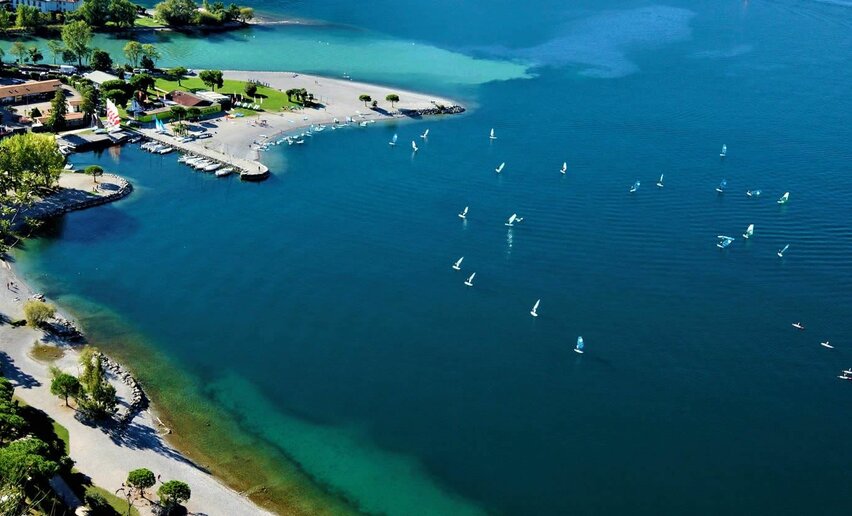
The tour is on the part of the lake in front of Riva del Garda. Right from the outset you get a chance to get a new perspective of the lakefront and town centre with its picturesque harbour in the shadow of the Torre Apponale. Leaving Riva at your back, head towards the rocky cliff of Rocchetta which here towers above Lake Garda. The Ponale trail, one of the best-love and most well-known hiking routes in the area, is clearly visible from the water.

Continue along beneath the rocky cliff until you come to the old Ponale harbour, once an important trading and communications hub between the Ledro valley and the Garda area. The Ponale Waterfall is hidden away in a little gorge and is one of the wildest and least frequented places in Trentino: the waterfall and its basin is only accessible from the lake, so only a fortunate few get a chance to enjoy its beauty.

Further information and useful links
Route info
Difficult
Route number
Distance
6,6 km
Activity time
2 h 00 min
Altitude difference (+)
0 m
Altitude difference (-)
0 m
Technical skills
Physical effort
Scenary
Highest point
62 m
Lowest point
62 m
Suggestions
The area of Ponale Waterfall was the ancient access to Ledro until 1851: here there was the harbor and the start of a mule track leading to Lake Ledro
Safety guidelines

7 Tips to SUP in safety

  • Always find out about the winds, weather and water conditions. The lake is subject to currents and steady winds which in the afternoon can make the water rough so that sup becomes difficult for beginners.
  • If you are planning solo sessions, always tell some where you are going and what time you are leaving. Use schools or the sup club as a base.
  • Keep to the coast but stay 500/600m from the shore and the cliffs where there might be rock falls.
  • It is important to know how to swim in rough water and have the right equipment and proper clothing for the weather conditions. You must use a sup board with a volume suited to your abilities and wear an CE approved personal buoyancy aid.
  • Always tie on the leash; the coast or shore might be far away and in case of problems you should never abandon the sup.
  • Find out about any local ordinances and ask locals for advice
  • Enjoy yourself. Sup combines a love of sport and nature and the beauty of Garda Trentino.

The information on this chart is subject to inevitable variations, so this means that none of the indications are absolute. It is not entirely possible to avoid giving inexact or imprecise information, given how quickly environmental and weather conditions can change. For this reason we decline any responsibility for changes which the user may encounter. In any case,  the hiker is advised to check the conditions of the places, environment and weather before setting out.

Punto di partenza
Purfina Beach - Riva del Garda
Directions

You leave from Purfina,  a busy beach just beyond the tourist harbour of San Nicolò. Paddle the length of Sabbioni beach as far as the magnificent Punta Lido where you have a stunning view over the gulf of Riva del Garda and you can stop off for a while in the estuary of the Varone and Albola streams.

To avoid the harbour area where sup boards are not allowed,  cross the lake in the area right in front of the centre of Riva del Garda, and go as far as the statue of Cristo del Lago, by Fra Silvio Bottes, a well-known local artist. The statue can only be seen from the water right below the start of the famous Ponale Trail. 

From here on, follow the Serenella rock wall, a cliff which rises sheer above Lake Garda. Passing a series of little inlets with turquoise blue water,  you finally arrive at the Sperone beach where you are advised to stop off for a break; continue then along the shore to the south until you come to a little gorge where you will find the waterfall of the Ponale stream as well as Ponale harbour, hidden by the lush vegetation which protects this spectacularly beautiful place.

On the return trip you should cut across the lake to get back to the beach you started from.

public transportation

The towns in Garda Trentino - Riva del Garda, Torbole sul Garda, Nago and Arco – are connected by a number of urban and intercity bus lines which will take you to the starting point or in the immediate surroundings.

For up-to-the-minute information on timetables and routes: www.gardatrentino.it

How to get there

Getting to northern lake Garda / Garda Trentino: www.gardatrentino.it

Where to park

The car park nearest to the point of departure is Porto San Nicolò (pay parking).

Free parking in Riva del Garda at the old hospital (via Rosmini) and the old cemetery (Viale D. Chiesa). Further pay parking at the Public Gardens Porta Orientale, Roman Baths, Viale Lutti (Ex Agraria), Monte Oro, shopping center Blue Garden.

In spring and summer you are advised to wear a semi-drysuit, in summer all you need is a swimsuit and lycra suit. You always need to wear a life jacket. 
Riva del Garda
open
closed
water sport
Torbole sul Garda - Nago
open
closed
water sport
Torbole sul Garda - Nago
open
closed
windsurf
You might be interested in
Discover related tours
Torbole sul Garda - Nago, Riva del Garda
Distance 2,4 km
Activity time 30 min
Altitude difference (+) 0 m
Status
open
Riva del Garda
Distance 5,0 km
Activity time 35 min
Altitude difference (+) 0 m
Status
open
Riva del Garda
Distance 3,5 km
Activity time 45 min
Altitude difference (+) 0 m
Status
open
Torbole sul Garda - Nago, Riva del Garda
Distance 4,9 km
Activity time 1 h 30 min
Altitude difference (+) 0 m
Status
open
Riva del Garda, Torbole sul Garda - Nago
Distance 7,5 km
Activity time 2 h 00 min
Altitude difference (+) 0 m
Status
open
Ledro
Distance 8,3 km
Activity time 2 h 30 min
Altitude difference (+) 0 m
Status
open