aria.quick_link.navi aria.quick_link.skiptomaincontent aria.quick_link.footer
Garda Trentino Logo
Top

Sentiero della Maestra- "Teacher's Trail" in Val del Sarca

Arco, Dro & Drena

Category
Difficulty
Intermediate
Duration
4:15
Duration in hours
Distance
11.6
Distance in km
Status
open
WSEN
Suggested period
Jan
Feb
Mar
Apr
May
Jun
Jul
Aug
Sep
Oct
Nov
Dec

Hike through the woods which cover the eastern slopes of the Sarca Valley from Bosco Caproni to the little hamlet of Braila, home of the schoolmistress for whom this trail is named

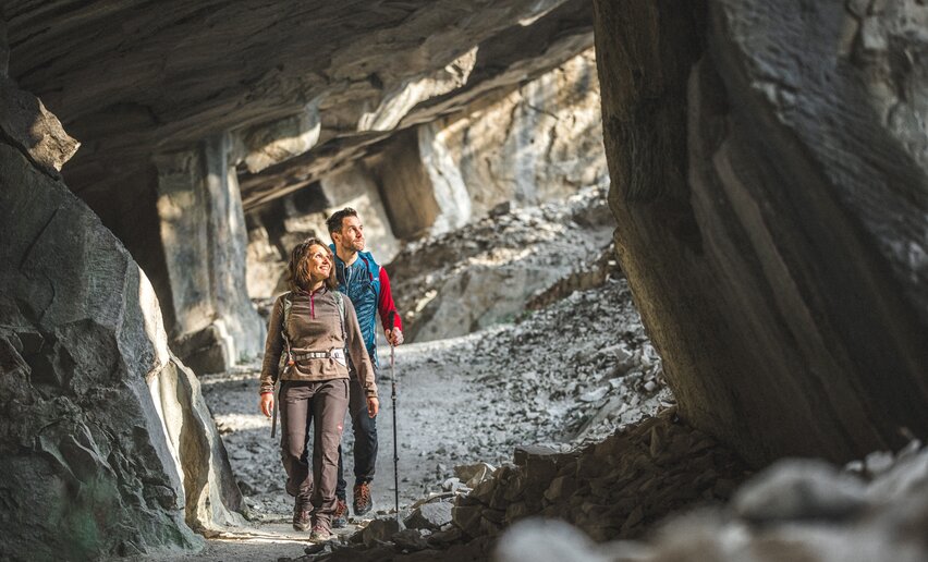
The trail winds among olive groves before it comes to what look like mysterious cave mouths on the mountainside, the oolite quarries of Bosco Caproni. Continue on through the woods along the Varino ridge which rises above the River Sarca with spectacular views of the valley. On the way back you pass through terraced vineyards which follow the course of the river. In a single trail the hiker can enjoy all the variety that Garda Trentino has to offer.

Further information and useful links

For more information on routes, services (guides, mountain huts, shops etc.) and hiking friendly accommodation: Garda Trentino - +39 0464 554444

details
  • Scenic
  • Round trip
  • Cultural/historical interest
  • Flora
  • Secured passages
Route info
Intermediate
Route number
Distance
11,6 km
Duration
4 h 15 min
Altitude difference (+)
495 m
Altitude difference (-)
493 m
Physical effort
Scenary
Highest point
581 m
Lowest point
93 m
Suggestions

This trail follows the route the schoolmistress Ketty Tantardini Bombardelli had to take in the 1920s to get to Braila, where she taught in school. 

You might be interested in
Discover related tours
Bunker from WWII - Dos Tenim (Nago - Torbole) | © Staff Outdoor GardaTrentino MM, Garda Trentino
Intermediate
Torbole sul Garda - Nago, Arco, Riva del Garda
The "Blue Line" of Garda Trentino
Distance 15,2 km
Duration 5 h 20 min
Altitude difference (+) 291 m
Altitude difference (-) 293 m
Status
open
Giro delle cime | © Stefania Oradini, Garda Trentino
Difficult
Tenno, Comano, Riva del Garda, Ledro
Summit Tour
Distance 25,8 km
Duration 11 h 00 min
Altitude difference (+) 2.488 m
Altitude difference (-) 2.488 m
Status
open
Monte Corno | © Archivio Garda Trentino (ph. Tommaso Prugnola), Garda Trentino
Intermediate
Arco, Torbole sul Garda - Nago, Surroundings
WWI: Monte Corno
Distance 6,9 km
Duration 3 h 10 min
Altitude difference (+) 560 m
Altitude difference (-) 560 m
Status
open
Meadows of Ca' de Mez | © Archivio Garda Trentino, Garda Trentino
Intermediate
Ledro
Malga Giù - San Martino
Distance 13,3 km
Duration 5 h 00 min
Altitude difference (+) 700 m
Altitude difference (-) 700 m
Status
open
Walking in the woods | © Fototeca Trentino Sviluppo foto di A. Russolo, Garda Trentino
Intermediate
Comano
Malga Plaz
Distance 10,2 km
Duration 4 h 22 min
Altitude difference (+) 980 m
Altitude difference (-) 980 m
Status
open
Trekking to the San Pietro Refuge | © Archivio Garda Trentino (ph. Tommaso Prugnola), Garda Trentino
Intermediate
Tenno
Hike to Rifugio San Pietro
Distance 5,2 km
Duration 2 h 45 min
Altitude difference (+) 510 m
Altitude difference (-) 510 m
Status
open