aria.quick_link.navi aria.quick_link.skiptomaincontent aria.quick_link.footer
Garda Trentino Logo
Top

From Malga Campo to Rifugio Altissimo above Lake Garda

Torbole sul Garda - Nago

Category
Difficulty
Intermediate
Duration
3:35
Duration in hours
Distance
9.4
Distance in km
Status
open
WSEN
Suggested period
Jan
Feb
Mar
Apr
May
Jun
Jul
Aug
Sep
Oct
Nov
Dec

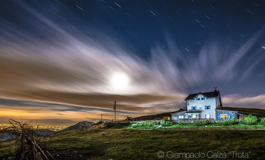
The mountain hut Rifugio Damiano Chiesa on Monte Altissimo is one of the most popular destinations with hikers in Garda Trentino. This is a variation on the usual route for you to try

This hike gives you the chance to explore the face of Monte Baldo where the hut Rifugio Damiano Chiesa is situated. The area is extremely popular with hikers who can enjoy the local flora, spectacular panoramas and finally wind up with some hearty local food when they get to the hut.

This trek is through the Monte Baldo Local Nature Reserve, a protected area notable for its exceptional biodiversity. Monte Baldo has been renowned for its extraordinary variety of plants and flowers since the 15th century when it was known as the “Garden of Europe”

All around the mountain hut Rifugio Damiano Chiesa there are still remains of tunnels and trenches dating back to the Great War. This outpost was taken by the Italian army without any bloodshed in the early stages of the war and became the front line of the Italian Front and an important observation point over the Alto Garda area

Further information and useful links

For more information on routes, services (guides, mountain huts, shops etc.) and hiking friendly accommodation: Garda Trentino - +39 0464 554444

details
  • Scenic
  • Summit route
  • Round trip
  • Cultural/historical interest
  • Flora
Route info
Intermediate
Route number
Distance
9,4 km
Duration
3 h 35 min
Altitude difference (+)
508 m
Altitude difference (-)
508 m
Physical effort
Scenary
Highest point
2.051 m
Lowest point
1.609 m
Suggestions

Do not miss the occasion to taste the typical food of the Rifugio D. Chiesa on the top of Monte Altissimo!

The Monte Baldo Local Nature Reserve has many hiking trails with panels providing information about the particular features of the park. A list can be found on the reserve website

The trail SAT 601 is part of the Sentiero della Pace (or Peace Trail), a long distance trail which links the most important points along the Front during the First World War in Trentino. 

You might be interested in
Discover related tours
Walking passion | © Fototeca Trentino Sviluppo foto di A. Russolo, Garda Trentino
Intermediate
Comano
Monte S. Martino
Distance 6,2 km
Duration 3 h 00 min
Altitude difference (+) 429 m
Altitude difference (-) 429 m
Status
open
On Monte Cocca | © Natalia Pellegrini, Garda Trentino
Intermediate
Ledro
Monte Cocca
Distance 8,4 km
Duration 3 h 30 min
Altitude difference (+) 750 m
Altitude difference (-) 750 m
Status
open
Prada Meadows | © Archivio Garda Trentino (ph. Watchsome), Garda Trentino
Easy
Valle dei Laghi
Prati di Prada and the Lakes of Lamar
Distance 8,1 km
Duration 2 h 30 min
Altitude difference (+) 260 m
Altitude difference (-) 260 m
Status
open
View over Lake Garda from the trenches of Monte Corno | © Associazione 1 Territorio 2 Fronti, Garda Trentino
Easy
Torbole sul Garda - Nago
WWI: Monte Corno and Busa dei Capitani
Distance 3,4 km
Duration 1 h 45 min
Altitude difference (+) 317 m
Altitude difference (-) 316 m
Status
open
Dosso Alto | © A. Pizzato - montagnadiviaggi.it, Garda Trentino
Intermediate
Surroundings, Torbole sul Garda - Nago
Great War: Doss Casina and Dosso Alto
Distance 7,2 km
Duration 3 h 20 min
Altitude difference (+) 448 m
Altitude difference (-) 452 m
Status
partially open
Monte Corno | © Archivio Garda Trentino (ph. Tommaso Prugnola), Garda Trentino
Intermediate
Arco, Torbole sul Garda - Nago, Surroundings
WWI: Monte Corno
Distance 6,9 km
Duration 3 h 10 min
Altitude difference (+) 560 m
Altitude difference (-) 560 m
Status
open