A short urban trail to discover the historic centre of Arco, perfect for anybody on their first visit to Garda Trentino who wants to find out more about the town.
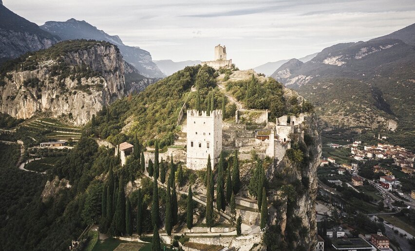
Arco is a small town nestled about a rocky outcrop crowned by the ruins of the castle, the symbol of the town. The castle dates back to the year one thousand, but archaeological excavations on the site unearthed traces of human presence well before the medieval period.
Thanks to the mild climate, pure healthy air and location a short distance from Lake Garda, Arco has over the years become a famous health resort, particularly popular with the Habsburg nobility at the turn of the twentieth century.
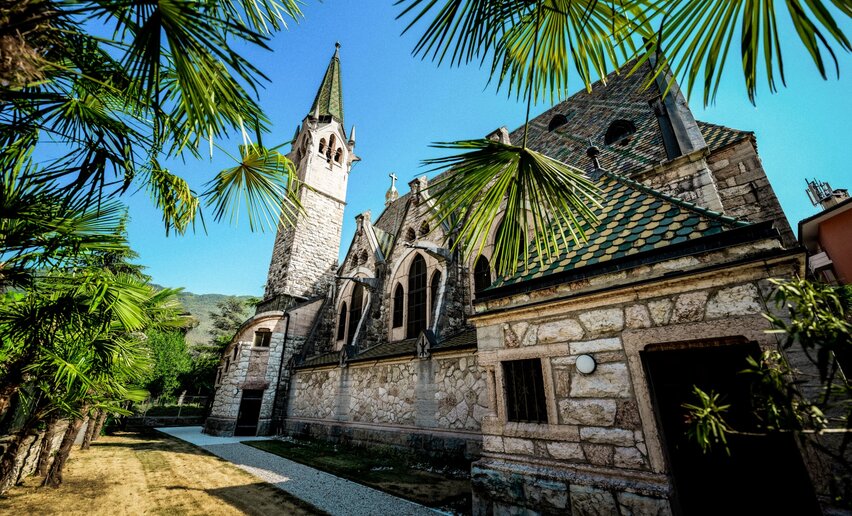
This strolllinks up the main monuments in the historic centre of the town with an itinerary that is easy and accessible to all, passing through the different historical periods of the town. From Renaissance palaces to Central European elegance, Arco truly offers an incredible variety and range for sightseeing.
Warning! The path up the hill to the Castle is not accessible to buggies and wheelchairs.
Arco is the birthplace of the Divisionist painter Giovanni Segantini and there is a statue in the town park to commemorate him.
The telephone number for the emergency services is 112.
The information on this chart is subject to inevitable variations, so this means that none of the indications are absolute. It is not entirely possible to avoid giving inexact or imprecise information, given how quickly environmental and weather conditions can change. For this reason we decline any responsibility for changes which the user may encounter. In any case, the hiker is advised to check the conditions of the places, environment and weather before setting out.
First part:
You leave from the Tourist Information Office in viale delle Palme, opposite the town Casino. When you come to the fountain, cross via Garberie and go on straight onto via Roma, for a detour at the Evangelical Church with its particular roof made of multicoloured tiles.
When you get back to the fountain, cross the public gardens to the parish church of Arco, known as the Collegiata. Leaving the church on your left, go around the back of it and on the right you will come to Palazzo Marchetti (famed for its Venetian chimney pots) and the Town Hall. In Piazza 3 Novembre, make sure to take a look at the fountain “del Mosè” and, opposite the church, Palazzo Marcabruni-Giuliani. Leave this building on your right and turn into via Vergolano: on the right hand side of the road you can see the historic building Palazzo del Termine o delle Lega. Keep straight on until you come to the junction with via Fossa Granda, which you follow to the left up as far as the arboretum (Parco Arciducale). To continue, enter the old town of Arco through the Stranfora gate, across the road from the park entrance.
Second Part (the Castle):
In piazza Stranfora turn left and go up via Orbia in the direction of Arco Castle (elevation gain c. 200m.) At the end of your visit, return the way you came as far as the sign for the “Rilke Promenade”, where you take the path through the olive grove, leading first to a panoramic viewing point overlooking the historic centre and then on to piazza San Giuseppe. Here you will find Palazzo Panni, home to the Galleria Segantini. Now follow via Segantini back to Piazza 3 Novembre and from there to the point you started from.
The towns in Garda Trentino - Riva del Garda, Torbole sul Garda, Nago and Arco – are connected by a number of urban and intercity bus lines which will take you to the starting point of the trail. For up-to-the-minute information on timetables and routes: www.gardatrentino.it
Getting to northern lake Garda / Garda Trentino: www.gardatrentino.it
Free parking in Caneve (5 minutes on foot from the centre of Arco).
Pay parkng Foro Boario, Via Caproni Maini (Parcheggio al Ponte), Posta (Via Monache).
This excursion is quite simple and presents no particular difficulty. However, we still recommend you to wear suitable footwear, a hat, sun screen and sunglasses. And be sure to bring water!
Distance | 8,6 km | |
---|---|---|
Activity time | 2 h 30 min | |
Altitude difference (+) | 220 m | |
Status |
open
|
Distance | 6,4 km | |
---|---|---|
Activity time | 1 h 30 min | |
Altitude difference (+) | 82 m | |
Status |
open
|
Distance | 3,0 km | |
---|---|---|
Activity time | 1 h 00 min | |
Altitude difference (+) | 117 m | |
Status |
open
|
Distance | 2,6 km | |
---|---|---|
Activity time | 1 h 15 min | |
Altitude difference (+) | 107 m | |
Status |
open
|
Distance | 15,2 km | |
---|---|---|
Activity time | 6 h 42 min | |
Altitude difference (+) | 1.412 m | |
Status |
open
|
Distance | 5,1 km | |
---|---|---|
Activity time | 2 h 00 min | |
Altitude difference (+) | 148 m | |
Status |
open
|
Official website of Garda Dolomiti – Azienda per il Turismo S.p.A. - C.F. e P. IVA 01855030225
Cap. Soc. € 600.000,00 I.V. - REA N. 182762