aria.quick_link.navi aria.quick_link.skiptomaincontent aria.quick_link.footer
Garda Trentino Logo
Top

The Archaeological Area San Martino in Campi

Riva del Garda

Category
Difficulty
Easy
Duration
1:05
Duration in hours
Distance
2.3
Distance in km
Status
open
Suggested period
Jan
Feb
Mar
Apr
May
Jun
Jul
Aug
Sep
Oct
Nov
Dec

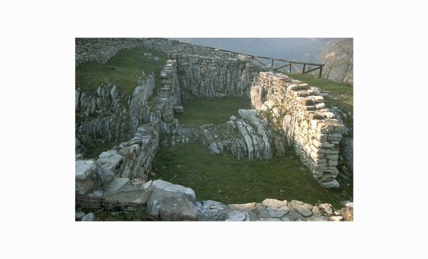
An easy walk to the San Martino Archaeological Area near Campi by Riva del Garda


The archeological site San Martino is one of the most important of Garda Trentino. Excavations uncovered a place of worship dating back to Pre-Roman times (3rd- 1st century B.C.) which in the middle of the first century B.C. was converted into a Roman sanctuary (1st century B.C. - 4th century A.D.), with the addition of a monumental staircase which can still be used today. This building, perched at the edge of the cliff, offers a breathtaking view over the towns beneath. Another few minutes and you come to the ruins of a village abandoned due to fire in the 8th century A.D. Here you can just make out the ruins of a little church dedicated to San Martino (8th -18th century A.D.)

Further information and useful links

For more information on routes, services (guides, mountain huts, shops etc.) and hiking friendly accommodation: Garda Trentino - +39 0464 554444


Route info
Easy
Route number
Distance
2,3 km
Duration
1 h 05 min
Altitude difference (+)
140 m
Altitude difference (-)
125 m
Physical effort
Scenary
Highest point
866 m
Lowest point
741 m
Suggestions

The findings unearthed on the site are located in the MAG Museum of Riva del Garda (www.museoaltogarda.it) and the Documentation Center in Pranzo (reservation required, tel. +39 349 4952623).

Uphill from the archeological area the itinerary passes through a chestnut grove. The sweet chestnut tree was widely grown in Trentino as elsewhere because of the major economic importance it had for mountain people who depended on it as a subsistence food. The fruit of this tree is highly nutritious and formed an important part of the local diet. Testimony to this are the numerous chestnut woods in Garda Trentino, including those in Drena, Pranzo, Tenno and Campi. Today the "maroni" (larger and tastier than normal chestnuts) play a major part in the menu for festivals and speciality menus for the autumn season.

You might be interested in
Discover related tours
Torbole sul Garda | © Archivio APT Garda Trentino (ph. Fabio Staropoli) , North Lake Garda Trentino
Easy
Torbole sul Garda - Nago, Riva del Garda, Arco
Sentiero della Pace 10: Riva del Garda to Torbole-Nago
Distance 6,4 km
Duration 1 h 55 min
Altitude difference (+) 159 m
Altitude difference (-) 16 m
Status
open
View on lake Toblino and Valle dei Laghi | © Archivio APT Garda Trentino (ph. R. Kiaulehn), North Lake Garda Trentino
Intermediate
Valle dei Laghi
Monte Gazza: view of the 4 lakes
Distance 13,0 km
Duration 7 h 00 min
Altitude difference (+) 900 m
Altitude difference (-) 900 m
Status
open
The village of Rango | © Archivio Garda Trentino (ph. Watchsome), Garda Trentino
Intermediate
Comano
Rango, Balbido and Passo Durone
Distance 8,3 km
Duration 2 h 45 min
Altitude difference (+) 357 m
Altitude difference (-) 357 m
Status
open
Canyon Limarò | © Fototrekking Foto D. Lira, North Lake Garda Trentino
Intermediate
Comano
Sentiero dell'Acqua
Distance 10,2 km
Duration 3 h 15 min
Altitude difference (+) 416 m
Altitude difference (-) 416 m
Status
open
Lake Garda and Monte Bondone from the Paganella peak | © Jennifer Paissan, Garda Trentino
Difficult
Valle dei Laghi
Mount Terlago - Paganella summit
Distance 12,2 km
Duration 6 h 35 min
Altitude difference (+) 1.536 m
Altitude difference (-) 1.536 m
Status
open
© A. Pizzato - montagnadiviaggi.it, Garda Trentino
Intermediate
Surroundings, Torbole sul Garda - Nago
Great War: Doss Casina and Dosso Alto
Distance 7,2 km
Duration 3 h 20 min
Altitude difference (+) 448 m
Altitude difference (-) 452 m
Status
open