aria.quick_link.navi aria.quick_link.skiptomaincontent aria.quick_link.footer
Garda Trentino Logo
Top

Malcesine Panoramic Road

Torbole sul Garda - Nago

Category
Difficulty
Intermediate
Duration
2:49
Duration in hours
Distance
34.6
Distance in km
Status
open
Suggested period
Jan
Feb
Mar
Apr
May
Jun
Jul
Aug
Sep
Oct
Nov
Dec

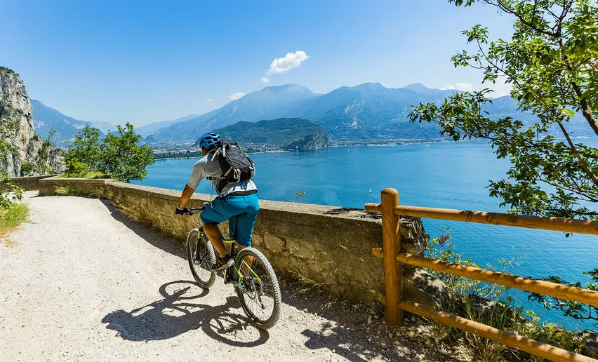
A brief tour characterised by the panoramic road in Malcesine which offers an opportunity to view Lake Garda from a different perspective. Quite a tough climb, but suitable for everyone.

The routes that offer a marvellous view of Lake Garda are truly too many to mention. This tour takes in most of the east coast of the lake.

We set off from Torbole then reach the Campiano Pass, a panoramic point above the town of Malcesine. Its olive groves, famous for producing one of the finest olive oils in Italy, frame a setting that is one of a kind. At the pass, there is a fountain to cool us down, whereas the descent offers a striking view, with the blue waters of the lake blending into the green of the olive trees.

A relatively short route, suitable for all cyclists. The climb is short, and the gradients are not taxing. A morning departure and afternoon return trip will ensure that we constantly benefit from a favourable wind.


Further information and useful links
From epic climbs to fast descents, every detail matters. Ride worry-free with help from our road cycling specialists: rentals, mechanics and guides who speak your language – the language of smooth tarmac and two wheels.
Route info
Intermediate
Route number
Distance
34,6 km
Duration
2 h 49 min
Altitude difference (+)
432 m
Altitude difference (-)
432 m
Technical skills
Physical effort
Scenary
Highest point
368 m
Lowest point
64 m
Suggestions

As also suggested by the name of the itinerary, there are lots of opportunities along this route to see a unique panorama. So, don’t forget your camera!

You might be interested in
Discover related tours
The little harbour in Torbole | © Archivio Garda Trentino, Garda Trentino
Difficult
Torbole sul Garda - Nago, Surroundings
Monte BaldoTour
Distance 116,9 km
Duration 8 h 00 min
Altitude difference (+) 2.300 m
Altitude difference (-) 2.300 m
Status
open
Malga Campo | © APT Garda Trentino (ph. Matteo ISchia) , Garda Trentino
Difficult
Riva del Garda, Dro & Drena, Arco
Drena - Malga Campo
Distance 54,0 km
Duration 5 h 00 min
Altitude difference (+) 1.328 m
Altitude difference (-) 1.328 m
Status
open
View on lake Toblino and Valle dei Laghi | © Archivio APT Garda Trentino (ph. R. Kiaulehn), North Lake Garda Trentino
Intermediate
Valle dei Laghi, Arco, Dro & Drena
Tour della Valle dei Laghi
Distance 64,8 km
Duration 4 h 25 min
Altitude difference (+) 570 m
Altitude difference (-) 570 m
Status
open
© Dario Zontini, Garda Trentino
Intermediate
Ledro
Lago di Ledro - Lago di Idro
Distance 51,9 km
Duration 4 h 00 min
Altitude difference (+) 680 m
Altitude difference (-) 680 m
Status
open
Tenno | © Archivio Garda Trentino (ph. Promovideo), Garda Trentino
Intermediate
Riva del Garda, Tenno
Tour del Lago di Tenno
Distance 22,0 km
Duration 1 h 45 min
Altitude difference (+) 567 m
Altitude difference (-) 567 m
Status
open
On the road to Monte Velo | © APT Garda Trentino (FotoFiore), Garda Trentino
Difficult
Valle dei Laghi, Dro & Drena, Val di Gresta, Arco, Riva del Garda
Monte Velo - Passo Santa Barbara - Monte Bondone
Distance 102,7 km
Duration 7 h 00 min
Altitude difference (+) 2.726 m
Altitude difference (-) 2.738 m
Status
open