aria.quick_link.navi aria.quick_link.skiptomaincontent aria.quick_link.footer
Garda Trentino Logo
Top

From Nago to the summit of Monte Altissimo

Torbole sul Garda - Nago, Surroundings

Category
Difficulty
Intermediate
Duration
4:00
Duration in hours
Distance
8.6
Distance in km
Status
open
Suggested period
Jan
Feb
Mar
Apr
May
Jun
Jul
Aug
Sep
Oct
Nov
Dec

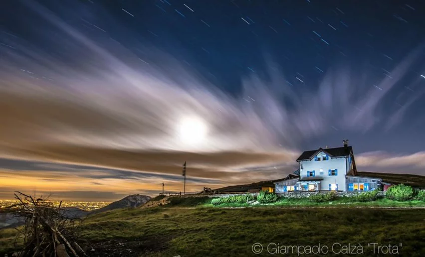
Monte Altissimo is one of the most popular destinations with hikers in Garda Trentino who are drawn by its wonderful lake views which change with every bend along the trail.

This trail is a section of the Peace Trail or Sentiero della Pace in Trentino, a long-distance trail which touches on points of major interest on what was the Front during the Great War. All the mountainside above Nago bears traces of the Austro-Hungarian defences, tunnels and barricades which recall the distant days of the First World War.

This trek runs through the Monte Baldo Local Nature Reserve, a protected area notable for its exceptional biodiversity. Monte Baldo has been renowned since the 15th century for its extraordinary variety of plants and flowers and known as the “Garden of Europe”.

Further information and useful links

For more information on routes, services (guides, mountain huts, shops etc.) and hiking friendly accommodation: Garda Trentino - +39 0464 554444


details
  • Linear route
  • Scenic
  • Refreshment stops available
  • Flora
Route info
Intermediate
Route number
Distance
8,6 km
Duration
4 h 00 min
Altitude difference (+)
761 m
Altitude difference (-)
762 m
Physical effort
Scenary
Highest point
2.069 m
Lowest point
1.308 m
Suggestions

Don't miss the chance to try some of the typical dishes from the Trentino cuisine at hut Damiano Chiesa! 

The Monte Baldo Local Nature Reserve has many hiking trails with panels providing information about the particular features of this fascinating reserve. A list can be found on the website of the reserve


You might be interested in
Discover related tours
© Natalia Pellegrini, Garda Trentino
Easy
Ledro
Cima Avez
Distance 9,1 km
Duration 2 h 00 min
Altitude difference (+) 258 m
Altitude difference (-) 252 m
Status
open
Blooming at Sant'Anna | © Archivio Garda Trentino (ph. Fabrizio Novali), Garda Trentino
Difficult
Ledro
Ledro Trek Medium - Stage 2
Distance 16,6 km
Duration 6 h 30 min
Altitude difference (+) 1.255 m
Altitude difference (-) 1.193 m
Status
open
Archeological Area San Martino (Riva del Garda loc. Campi) | © Marco Meiche, Garda Trentino
Easy
Riva del Garda
The Archaeological Area San Martino in Campi
Distance 2,3 km
Duration 1 h 05 min
Altitude difference (+) 140 m
Altitude difference (-) 125 m
Status
open
Daffodils filled meadows in Dromaé | © Archivio Garda Trentino (ph. Roberto Vuilleumier), Garda Trentino
Intermediate
Ledro
Blooming in Dromaè
Distance 12,1 km
Duration 5 h 52 min
Altitude difference (+) 978 m
Altitude difference (-) 978 m
Status
open
The hut Pernici - Bocca di Trat | © Archivio APT Garda Trentino, North Lake Garda Trentino
Difficult
Ledro, Riva del Garda
2 days in the mountains of Garda Trentino and 1 night in Rifugio Pernici
Distance 25,4 km
Duration 13 h 45 min
Altitude difference (+) 2.086 m
Altitude difference (-) 2.086 m
Status
open
View towards Monte Carone | © Staff Outdoor Garda Trentino AC, Garda Trentino
Difficult
Ledro
Ledro Alps Trek Alpiedi - Leg 2: from Tremalzo to Bivacco Arcioni
Distance 23,7 km
Duration 8 h 00 min
Altitude difference (+) 1.138 m
Altitude difference (-) 2.021 m
Status
open