aria.quick_link.navi aria.quick_link.skiptomaincontent aria.quick_link.footer
Garda Trentino Logo
Top

From Malga Campo to Monte Stivo

Val di Gresta, Arco

Category
Difficulty
Intermediate
Duration
4:00
Duration in hours
Distance
8.4
Distance in km
Status
open
Suggested period
Jan
Feb
Mar
Apr
May
Jun
Jul
Aug
Sep
Oct
Nov
Dec

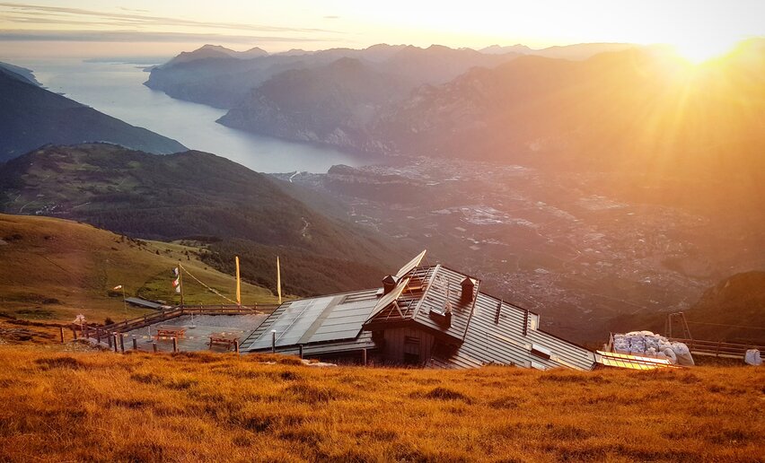
This is a trail for experienced hikers which leads to Cima Bassa and then along the ridge to the summit of Stivo, one of the most spectacular viewing points in Garda Trentino

The trail climbs among beech and larch woods before coming out above the tree-line where it begins to wind among rock, dwarf pine and rhodendron, the surroundings gradually changing as it rises to the summit of Monte Stivo at over 2000 metres above sea level.

There is an observation/viewing point near the mountain hut with a viewfinder and dial showing the names of all the surrounding peaks: Monte Baldo to the south, Brenta and Adamello to the west, and the lower Dolomites and Pasubio to the east

Further information and useful links

For more information on routes, services (guides, mountain huts, shops etc.) and hiking friendly accommodation: Garda Trentino - +39 0464 554444

details
  • Scenic
  • Summit route
  • Round trip
  • Refreshment stops available
  • Exposed sections
Route info
Intermediate
Route number
Distance
8,4 km
Duration
4 h 00 min
Altitude difference (+)
690 m
Altitude difference (-)
690 m
Physical effort
Scenary
Highest point
2.057 m
Lowest point
1.370 m
Suggestions

Along the trail there are many signs of the Great War. Stivo was in fact a second line of the Austro-Hungarian front and they left clearly visible traces of the defences.

You might be interested in
Discover related tours
Towards the summit of Monte Casale | © Archivio Garda Trentino (ph. Watchsome), Garda Trentino
Intermediate
Comano
Monte Casale
Distance 11,6 km
Duration 5 h 00 min
Altitude difference (+) 1.005 m
Altitude difference (-) 1.005 m
Status
open
Meadows of Ca' de Mez | © Archivio Garda Trentino, Garda Trentino
Intermediate
Ledro
Malga Giù - San Martino
Distance 13,3 km
Duration 5 h 00 min
Altitude difference (+) 700 m
Altitude difference (-) 700 m
Status
open
© Stefania Oradini, Garda Trentino
Intermediate
Riva del Garda, Ledro
Bocca Trat - Cima Parì
Distance 9,7 km
Duration 4 h 30 min
Altitude difference (+) 580 m
Altitude difference (-) 580 m
Status
open
Madonnina di Besta | © Archivio Garda Trentino (ph. Watchsome), Garda Trentino
Intermediate
Ledro
Giro della Madonnina di Besta
Distance 6,5 km
Duration 2 h 30 min
Altitude difference (+) 399 m
Altitude difference (-) 399 m
Status
open
Between Tofino and Roda | © Alessandro de Guelmi, Garda Trentino
Difficult
Ledro, Tenno, Comano, Riva del Garda
Ledro Alps Trek Alpiedi - Leg 4: from Rifugio Pernici to Bivacco Campel
Distance 18,2 km
Duration 8 h 00 min
Altitude difference (+) 1.653 m
Altitude difference (-) 1.551 m
Status
open
© APT Terme di Comano Dolomiti di Brenta, Garda Trentino
Intermediate
Comano
Malga Stabio e Cima Sèra
Distance 12,0 km
Duration 5 h 00 min
Altitude difference (+) 920 m
Altitude difference (-) 920 m
Status
open