aria.quick_link.navi aria.quick_link.skiptomaincontent aria.quick_link.footer
Garda Trentino Logo
Top

Tour del Lago di Tenno

Riva del Garda, Tenno

Category
Difficulty
Intermediate
Duration
1:45
Duration in hours
Distance
22
Distance in km
Status
open
Suggested period
Jan
Feb
Mar
Apr
May
Jun
Jul
Aug
Sep
Oct
Nov
Dec

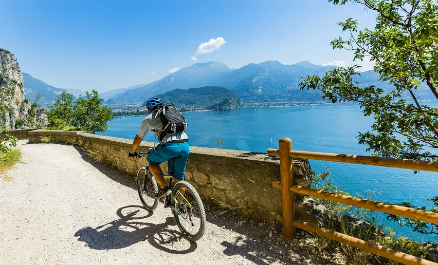
Another “classic” of the Garda Trentino area, this loop proposes the climb towards Lake Tenno. A short route with gradients that are not excessively challenging.

This itinerary is very popular with local cyclists, especially those with limited free time, who seek a short but intense route.

The starting point is in Riva del Garda. This version proposes the climb from Deva e Pranzo and the descent from Ville del Monte and Tenno. Again, the road is wide and not very busy. There are no flat sections, just this gentle climb about ten kilometres long, followed by a pleasant descent of the same distance.

The reasonable gradients mean that everyone can manage this route and enjoy its spectacular view of Lake Garda.

Further information and useful links
From epic climbs to fast descents, every detail matters. Ride worry-free with help from our road cycling specialists: rentals, mechanics and guides who speak your language – the language of smooth tarmac and two wheels.
details
  • Scenic
  • Round trip
  • Refreshment stops available
Route info
Intermediate
Route number
Distance
22,0 km
Duration
1 h 45 min
Altitude difference (+)
567 m
Altitude difference (-)
567 m
Technical skills
Physical effort
Scenary
Highest point
603 m
Lowest point
69 m
Suggestions

This route can also be tackled in the opposite direction: the distance and climb gradient are almost identical, as is the number of bends.

You might be interested in
Discover related tours
View from Ville del Monte - Tenno | © Archivio APT Garda Trentino, Garda Trentino
Difficult
Riva del Garda, Comano, Tenno
Tenno - Comano - Lago di Molveno - Paganella
Distance 134,3 km
Duration 8 h 00 min
Altitude difference (+) 2.560 m
Altitude difference (-) 2.560 m
Status
open
The hydroelectric plant in Riva del Garda | © APT Garda Trentino , Garda Trentino
Intermediate
Riva del Garda, Ledro
Limone - Tignale - Tremosine
Distance 62,9 km
Duration 5 h 00 min
Altitude difference (+) 2.786 m
Altitude difference (-) 2.788 m
Status
open
The tough climb to Padaro | © Archivio Garda Trentino (ph. Marco Giacomello), Garda Trentino
Intermediate
Arco, Dro & Drena, Riva del Garda
San Giovanni al Monte
Distance 32,4 km
Duration 2 h 30 min
Altitude difference (+) 2.166 m
Altitude difference (-) 2.167 m
Status
open
The Castle of Drena | © Archivio APT Garda Trentino (ph. Vuilleumier) , Garda Trentino
Difficult
Valle dei Laghi, Dro & Drena, Arco, Riva del Garda
Monte Bondone Tour
Distance 99,8 km
Duration 6 h 00 min
Altitude difference (+) 1.780 m
Altitude difference (-) 1.780 m
Status
open
Malga Campo | © APT Garda Trentino (ph. Matteo ISchia) , Garda Trentino
Difficult
Riva del Garda, Dro & Drena, Arco
Drena - Malga Campo
Distance 54,0 km
Duration 5 h 00 min
Altitude difference (+) 1.328 m
Altitude difference (-) 1.328 m
Status
open
On the road to Monte Velo | © APT Garda Trentino (FotoFiore), Garda Trentino
Difficult
Valle dei Laghi, Dro & Drena, Val di Gresta, Arco, Riva del Garda
Monte Velo - Passo Santa Barbara - Monte Bondone
Distance 102,7 km
Duration 7 h 00 min
Altitude difference (+) 2.726 m
Altitude difference (-) 2.738 m
Status
open