aria.quick_link.navi aria.quick_link.skiptomaincontent aria.quick_link.footer
Garda Trentino Logo
Top

18. From the Marmitte to Perlone between nature and geology

Torbole sul Garda - Nago, Arco

Category
Difficulty
Intermediate
Duration
2:30
Duration in hours
Distance
7.6
Distance in km
Status
open
WSEN
Suggested period
Jan
Feb
Mar
Apr
May
Jun
Jul
Aug
Sep
Oct
Nov
Dec

A trail which connects the Marmitte dei Giganti, spectacular geological pothole formations, with the Castagneto di Nago chestnut woods and the trenches of Busa dei Capitani. 

This trail focuses on some of the typical features of the Garda area, and all with a view of the lake. 

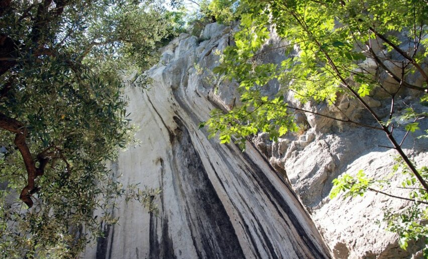
The Marmitte dei Giganti are glacial potholes (known as the Giants' Potholes) formed millions of years ago by the erosion of the rock. These great cavities have a diameter of 4 or 5 metres and are as deep as 12 metres. The potholes were formed by the melting of the glaciers which modelled the rock and polished its surface. The potholes often occur together with other natural karst phenomena such as striated rock, sheepbacks and glacial shift.

The sweet chestnut tree was widely grown in Trentino as elsewhere because of the major economic importance it had for mountain people who depended on it as a subsistence food. The fruit of this tree is highly nutritious and formed an important part of the local diet. 

 The Monte Corno area where the Castagneto chestnut wood is situated was on the Front held by the imperial Austro-Hungarian army during the First World War: there are still stretches of trenches and various buildings restored by local associations.

Further information and useful links

For more information on routes, services (guides, mountain huts, shops etc.) and hiking friendly accommodation: Garda Trentino - +39 0464 554444

Route info
Intermediate
Route number
Distance
7,6 km
Duration
2 h 30 min
Altitude difference (+)
469 m
Altitude difference (-)
469 m
Physical effort
Scenary
Highest point
535 m
Lowest point
66 m
Suggestions

Don't forget to take your camera: the view on lake Garda is really unforgettable! 

You might be interested in
Discover related tours
View from the little church San Pietro | © APT Garda Trentino, Garda Trentino
Intermediate
Tenno
A hike around Monte Calino, the mountain of Tenno
Distance 11,1 km
Duration 4 h 52 min
Altitude difference (+) 715 m
Altitude difference (-) 715 m
Status
open
Malga Cap | © Staff Outdoor Garda Trentino AC, Garda Trentino
Difficult
Ledro
Le Tre Sorelle: the Three Sisters
Distance 14,6 km
Duration 6 h 00 min
Altitude difference (+) 831 m
Altitude difference (-) 831 m
Status
open
View from Segrom | © Archivio APT Garda Trentino, North Lake Garda Trentino
Intermediate
Torbole sul Garda - Nago, Dro & Drena, Arco, Riva del Garda, Tenno
GardaTrek - Medium Loop: 4 stages around Garda Trentino
Distance 72,6 km
Duration 29 h 05 min
Altitude difference (+) 4.262 m
Altitude difference (-) 4.265 m
Status
open
Trekking Cima Nara | © VisitTrentino, Garda Trentino
Intermediate
Riva del Garda, Ledro
Trekking to Cima Bal and Cima Nara
Distance 10,2 km
Duration 4 h 55 min
Altitude difference (+) 915 m
Altitude difference (-) 900 m
Status
partially open
The mountain hut Rifugio San Pietro | © Archivio APT Garda Trentino (ph. Promovideo), North Lake Garda Trentino
Intermediate
Tenno
Hiking to the mountain hut San Pietro on Monte Calino
Distance 9,1 km
Duration 3 h 57 min
Altitude difference (+) 458 m
Altitude difference (-) 458 m
Status
open
The view from the Bastione | © Patrizia N. Matteotti (Archivio Garda Trentino) , Garda Trentino
Intermediate
Riva del Garda
Bastione and Santa Barbara, the lords of Riva del Garda
Distance 2,8 km
Duration 1 h 45 min
Altitude difference (+) 590 m
Altitude difference (-) 60 m
Status
open