aria.quick_link.navi aria.quick_link.skiptomaincontent aria.quick_link.footer
Garda Trentino Logo
Top

10. To the Hermitage Eremo di San Giacomo

Arco

Category
Difficulty
Intermediate
Duration
2:15
Duration in hours
Distance
4.2
Distance in km
Status
open
WSEN
Suggested period
Jan
Feb
Mar
Apr
May
Jun
Jul
Aug
Sep
Oct
Nov
Dec

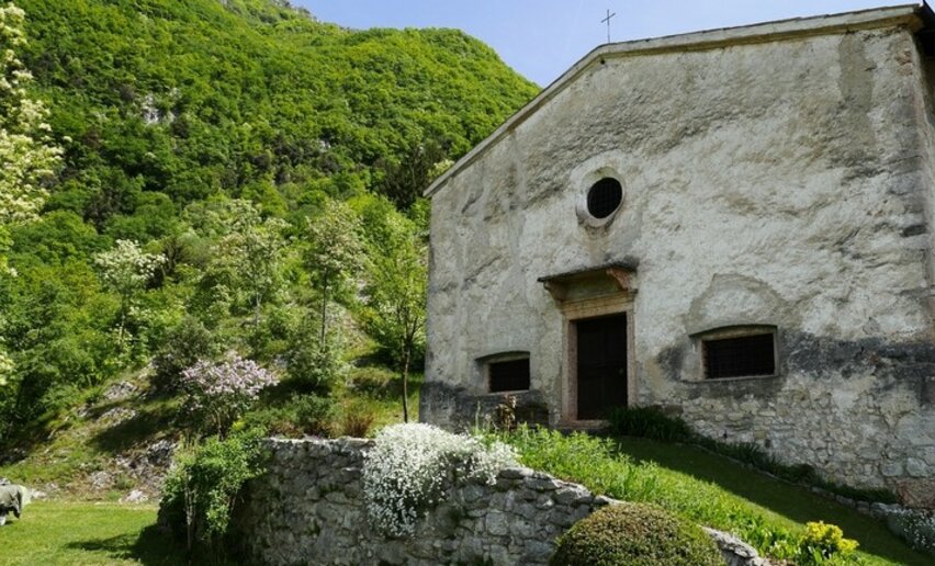
A hike up the slopes of Monte Stivo from Bolognano to the chapel which overlooks the town and the Arco area and offers a good view point.

The hermitage is mentioned in documents dating back to 1288, but its roots probably go back even further. It is situated on an ancient communications route connecting the Valle dell'Adige and Basso Sarca and gave shelter to wayfarers and pilgrims. The inhabitants of Bolognano still spend May Day at San Giacomo, a tradition which goes back centuries.

For anyone who would like to visit the hermitage but does not feel like hiking up from the town, it is possible to get to Salve Regina by car and from there it is only 20 minutes to the chapel along a forestry road (signpost SAT 609 and then follow directions for San Giacomo).

Further information and useful links

For more information on routes, services (guides, mountain huts, shops etc.) and hiking friendly accommodation: Garda Trentino - +39 0464 554444

details
  • Linear route
  • Scenic
  • Cultural/historical interest
Route info
Intermediate
Route number
Distance
4,2 km
Duration
2 h 15 min
Altitude difference (+)
615 m
Altitude difference (-)
8 m
Physical effort
Scenary
Highest point
744 m
Lowest point
129 m
Suggestions

The Hermitage of Santi Giacomo and Silvestro al Monte (more commonly known as San Giacomo) is usually open on Sundays in summertime.

You might be interested in
Discover related tours
Punta Larici | © Archivio Garda Trentino (ph. Watchsome), Garda Trentino
Intermediate
Riva del Garda
Punta Larici
Distance 8,6 km
Duration 4 h 00 min
Altitude difference (+) 640 m
Altitude difference (-) 637 m
Status
partially open
The Sarca Valley, seen from the "Teacher's route" | © Archivio APT Garda Trentino, Garda Trentino
Intermediate
Arco, Dro & Drena
Sentiero della Maestra- "Teacher's Trail" in Val del Sarca
Distance 11,6 km
Duration 4 h 15 min
Altitude difference (+) 495 m
Altitude difference (-) 493 m
Status
open
Descent - section with rope | © Archivio APT Garda Trentino, Garda Trentino
Intermediate
Dro & Drena, Arco
From Dro to Braila along the Teacher's Trail
Distance 10,9 km
Duration 4 h 30 min
Altitude difference (+) 455 m
Altitude difference (-) 454 m
Status
open
Belvedere di Bezzecca | © Graziano Venturini, Garda Trentino
Easy
Ledro
Belvedere of Bezzecca
Distance 7,4 km
Duration 3 h 00 min
Altitude difference (+) 324 m
Altitude difference (-) 324 m
Status
open
Monte Stivo - Visitrovereto | © ApT Rovereto Vallagarina Monte Baldo - Prodotto Outdoor, Garda Trentino
Intermediate
Arco, Val di Gresta
Ascent to Monte Stivo
Distance 14,5 km
Duration 6 h 21 min
Altitude difference (+) 890 m
Altitude difference (-) 892 m
Status
open
Ascent to Monte Altissimo | © Archivio Garda Trentino (ph. Watchsome), Garda Trentino
Intermediate
Torbole sul Garda - Nago
From Malga Campo to Rifugio Altissimo above Lake Garda
Distance 9,4 km
Duration 3 h 35 min
Altitude difference (+) 508 m
Altitude difference (-) 508 m
Status
open