Logo Garda
Top

Through Tenno and its villages

Riva del Garda, Tenno
Difficulty
Intermediate
Duration
3:10
Duration in hours
Distance
15.3
Distance in km
Status
open
Suggested period
Jan
Feb
Mar
Apr
May
Jun
Jul
Aug
Sep
Oct
Nov
Dec
A run through the amazing colours of Lake Tenno, passing through the ancient villages of the area.
A very runnable sprint ring, after the first 4 km in which most of the height difference is concentrated.

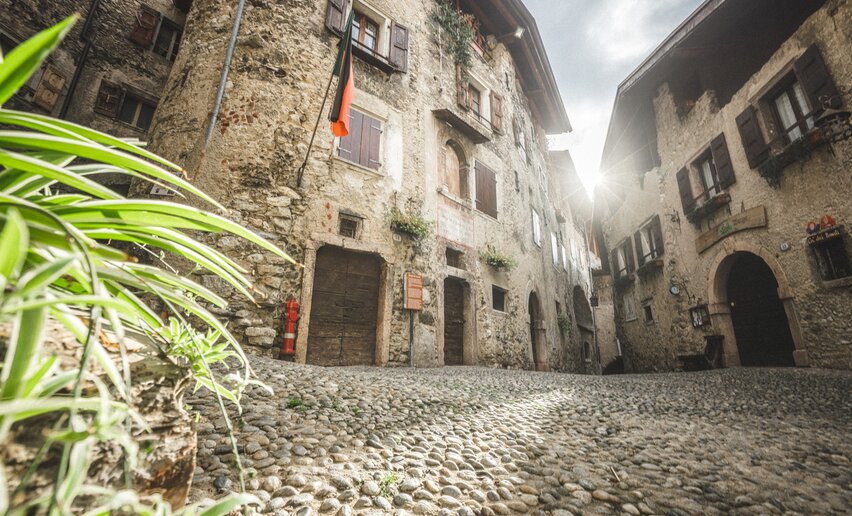
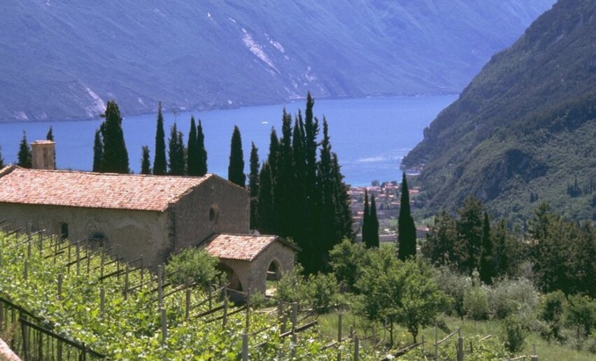
From Varone, two steep and enjoyable climbs (the Gola and Salt paths) take you first to the village of Calvola and then to the medieval village of Canale, which you cross passing the characteristic "faces" of the old trades. When you reach Lake Tenno, you first walk along the lake from above and then along its perimeter, admiring its colours (spectacular in autumn). From Ville del Monte, we return to Tenno, descending along a stretch of the "Molini" path, an ancient crossing of the Magnus River. the ancient crossing of the Magnone stream, then taking the diversions on the left that quickly leads to Tenno, through countryside and vineyards. From Tenno you enter the walls of the historic village of Frapporta, admiring the view of the upper lake and the BUSA (Riva-Arco) from the panoramic point of Il GROM and then descending towards Deva along the path that passes in front of the beautiful little church of San Lorenzo. From Deva, an express descent along Via Roncaglie.

Further information and useful links
For more information on routes and services: guides, shops and outdoor friendly friendly accommodation:  APT Garda Trentino, Tel. +39 0464 554444 www.gardatrentino.it 
Route info
Intermediate
Route number
Distance
15,3 km
Duration
3 h 10 min
Altitude difference (+)
685 m
Altitude difference (-)
685 m
Technical skills
Physical effort
Scenary
Highest point
712 m
Lowest point
115 m
Suggestions
Here, you can stop in the villages of Tenno, Canale and Frapporta, admire the view from the vantage point in GROM, stop and discover the San Lorenzo Church! 
Safety guidelines
The information on this chart is subject to inevitable variations, so this means that none of the indications are absolute. It is not entirely possible to avoid giving inexact or imprecise information, given how quickly environmental and weather conditions can change. For this reason, we decline any responsibility for changes which the user may encounter. In any case, the hiker is advised to check the conditions of the places, environment and weather before setting out.
Punto di partenza
Varone
public transportation
The towns in Garda Trentino - Riva del Garda, Torbole sul Garda and Arco – are connected by several urban and intercity bus lines which will take you to the starting point or in the immediate surroundings.

For up-to-the-minute information on timetables and routes: www.gardatrentino.it  

You can also get to Riva del Garda and Torbole sul Garda by the public ferry service. For up-to-the-minute information on timetables and routes: www.gardatrentino.it 

How to get there
Getting to northern lake Garda / Garda Trentino: www.gardatrentino.it  
Where to park
Parking space at the beginning of the trail 
Tenno
Calvola
hamlet
Canale di Tenno - Lake Garda
Tenno
Canale di Tenno
hamlet
Tenno
Borgo di Frapporta
hamlet
Tenno
Chiesa di San Lorenzo
church
You might be interested in
Discover related tours
Church from Tiarno di Sopra | © Staff Outdoor Garda Trentino AC, Garda Trentino
Intermediate
Ledro
Santi Pietro e Paolo
Distance 8,9 km
Duration 1 h 30 min
Altitude difference (+) 300 m
Altitude difference (-) 300 m
Status
open
Cima Giochello | © Garda Trentino Trail , Garda Trentino
Difficult
Riva del Garda
Vertical Crazidei
Distance 11,7 km
Duration 3 h 30 min
Altitude difference (+) 1.501 m
Altitude difference (-) 1.501 m
Status
closed
© Fabrizio Novali, Garda Trentino
Difficult
Riva del Garda, Ledro
Ledro Sky - Senter de le greste
Distance 18,7 km
Duration 4 h 30 min
Altitude difference (+) 1.650 m
Altitude difference (-) 1.650 m
Status
open
© Samuele Guetti, Garda Trentino
Difficult
Comano, Tenno, Ledro
Comano Ursus Extreme Trail
Distance 26,5 km
Duration 7 h 00 min
Altitude difference (+) 2.150 m
Altitude difference (-) 2.150 m
Status
open
View from Punta Larici | © Garda Trentino Trail , Garda Trentino
Difficult
Ledro, Riva del Garda
Ponale - Larici - Rocchetta
Distance 21,8 km
Duration 5 h 40 min
Altitude difference (+) 1.384 m
Altitude difference (-) 1.384 m
Status
open
View of the Lake Ledro | © Staff Outdoor Garda Trentino AC, Garda Trentino
Intermediate
Ledro
Coste di Bariolo
Distance 9,9 km
Duration 3 h 00 min
Altitude difference (+) 380 m
Altitude difference (-) 380 m
Status
open