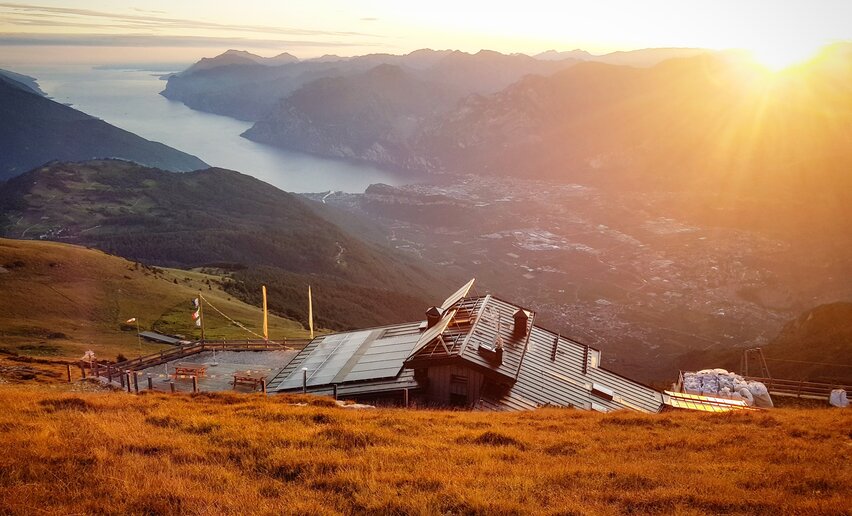
This stage takes you from 2000 metres on Monte Stivo to 220 metres in Nago and passes through a landscape which changes continually as you lose altitude, from alpine pasture to woodland and finally the olive groves and Mediterranean vegetation above the shores of Lake Garda.
A landscape which carries the signs of its past. When you are hiking on the trail SAT 637 near the Nago chestnut woods, you are on what used to be the Austrian Front Line during the Great War. Here local associations have restored the trenches and barricades in a number of areas and they are well worth a visit. You will discover a whole village hidden in the trees, with a lot of buildings and lookout points that will reward you with incredible views over northen lake Garda.
You can close your adventure on the Top Loop in Nago or rest before facing the next, challenging stage which will take you up to Monte Altissimo.
Don't forget to visit the ruins of Castel Penede, overlooking Torbole and lake Garda: it's really a dramatic place!
Head down from the mountain hut Rifugio Marchetti on trail SAT 608. Before you enter the woods at the other side of the meadows at the “Prese” turn right and continue downhill on SAT 608 as far as Malga Zanga. Now you are walking on a cemented dirt road until you come to a turn-off on the left. Continue down the paved track 608 as far as Rochi (Monte Velo) where you follow directions for the chapel of San Francesco. Stay on the dirt track as far as Malga Fiavei where you turn onto SAT 637 and keep going as far as Dorsale 3 Croci. Turn right and take the dirt road as far as a turn-off where you follow directions for the chestnut wood or castagneto. When you come out the other side of the chestnut wood continue on down the trail until you come to Nago. Along the way there are some lovely views of Nago and Lake Garda.
If you want to head back to Riva once in Nago, you can take the bus at the stop in Strada Rivana.
Information about lines and time tables: www.gardatrentino.it
No public transport available from the hut Prospero Marchetti to Nago.
Getting to northern lake Garda / Garda Trentino: www.gardatrentino.it
The trek proposed here does not have bolted routes or via ferratas, and so there is no need for helmets, harness or rope. However, considering how physically demanding the route is, the length of the stages and the presence of some exposed stretches, this type of trek is only recommended for people who are very fit, who have a good sense of direction and who are used to hiking in a mountain environment.
GardaTrek requires you to have standard hiking equipment for alpine terrain and we suggest you also bring a wind and waterproof jacket and fleece in case of bad weather, a torch, a change of underwear, sunglasses and sunscreen, a water canteen and snacks.
Distance | 13,7 km | |
---|---|---|
Activity time | 7 h 00 min | |
Altitude difference (+) | 1.822 m | |
Status |
open
|
Distance | 16,3 km | |
---|---|---|
Activity time | 7 h 50 min | |
Altitude difference (+) | 1.917 m | |
Status |
open
|
Distance | 11,6 km | |
---|---|---|
Activity time | 5 h 00 min | |
Altitude difference (+) | 678 m | |
Status |
closed
|
Distance | 92,7 km | |
---|---|---|
Activity time | 40 h 00 min | |
Altitude difference (+) | 4.259 m | |
Status |
open
|
Distance | 20,3 km | |
---|---|---|
Activity time | 7 h 55 min | |
Altitude difference (+) | 1.418 m | |
Status |
open
|
Distance | 92,5 km | |
---|---|---|
Activity time | 47 h 00 min | |
Altitude difference (+) | 7.956 m | |
Status |
open
|
Official website of Garda Dolomiti – Azienda per il Turismo S.p.A. - C.F. e P. IVA 01855030225
Cap. Soc. € 600.000,00 I.V. - REA N. 182762