aria.quick_link.navi aria.quick_link.skiptomaincontent aria.quick_link.footer
Garda Trentino Logo
Top

Vespana - Tour

Tenno

Category
Difficulty
Intermediate
Duration
3:05
Duration in hours
Distance
20.6
Distance in km
Status
open
Suggested period
Jan
Feb
Mar
Apr
May
Jun
Jul
Aug
Sep
Oct
Nov
Dec

Entertaining circuit on the slopes north of Tenno.

Signage: 740. Vespana - Tour

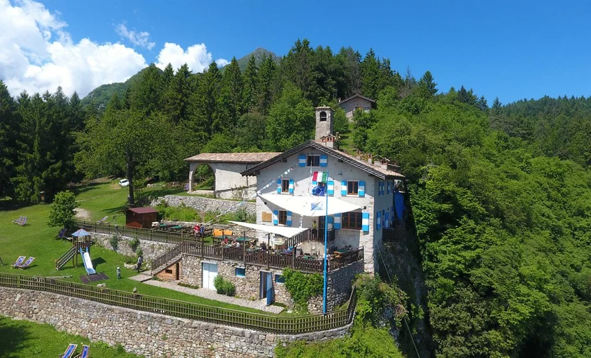
There’s never a dull moment on this tour. Varied climbs, descents and flat sections, changing terrain and a series of sights make for an unforgettable MTB experience. But let’s not get ahead of ourselves. Start by ascending to the picturesque medieval village of Canale di Tenno. From there things get flatter until you reach the shimmering, turquoise Lago di Tenno. After a long climb along the wooded slopes at the foot of Monte Misone, you have the option of branching off to Rifugio San Pietro, which is a lovely spot for a break, with its unique setting and beautiful views over Lake Garda. Shortly after that you arrive at the highest point of the tour at Sella di Calino. After reaching the hamlet of Vespana you have to climb again, then you coast along through woods and meadows, initially on gravel, later on tarmac, back to your starting point in Tenno.


Further information and useful links
Picked your route? Now find the right experts to go with it. Make the most of every ride with support from local MTB specialists – from guides and rentals to shuttle services and workshops.
Route info
Intermediate
Route number
740
Distance
20,6 km
Duration
3 h 05 min
Altitude difference (+)
730 m
Altitude difference (-)
730 m
Physical effort
Scenary
Highest point
967 m
Lowest point
414 m
Suggestions

Rifugio San Pietro is worth a short detour for refreshment halfway through the tour and to enjoy the view over Lake Garda.

You might be interested in
Discover related tours
View from Maso Naranch | © Archivio Garda Trentino (ph. Tommaso Prugnola), Garda Trentino
Difficult
Torbole sul Garda - Nago, Arco, Surroundings
Monte Corno Trail-Tour
Distance 20,2 km
Duration 3 h 35 min
Altitude difference (+) 980 m
Altitude difference (-) 980 m
Status
closed
Strada del Pil | © Archivio Garda Trentino (ph. Watchsome), Garda Trentino
Difficult
Valle dei Laghi, Torbole sul Garda - Nago, Arco, Dro & Drena, Riva del Garda, Tenno
Garda Sarca Loop
Distance 67,3 km
Duration 8 h 25 min
Altitude difference (+) 1.407 m
Altitude difference (-) 1.407 m
Status
closed
Ascent to Monte Brione | © Archivio Garda Trentino (ph. Tommaso Prugnola), Garda Trentino
Intermediate
Riva del Garda
Monte Brione Trail-Tour
Distance 6,2 km
Duration 50 min
Altitude difference (+) 240 m
Altitude difference (-) 240 m
Status
open
© Staff Outdoor GardaTrentino SO, Garda Trentino
Difficult
Comano, Tenno, Riva del Garda, Arco, Dro & Drena
2025 Bike Marathon Garda Trentino Ronda Grande
Distance 58,8 km
Duration 5 h 30 min
Altitude difference (+) 2.406 m
Altitude difference (-) 2.406 m
Status
open
Bikers during the Bike Marathon | © APT Garda Trentino , Garda Trentino
Difficult
Arco, Comano, Dro & Drena, Riva del Garda, Tenno
Ronda Extrema
Distance 88,8 km
Duration 8 h 00 min
Altitude difference (+) 4.199 m
Altitude difference (-) 4.162 m
Status
open
Towards Passo dei Gatùm from Passo Tremalzo | © Archivio Garda Trentino (ph. Giorgio Dubini), Garda Trentino
Difficult
Ledro
Tremalzo Big - Tour
Distance 45,8 km
Duration 6 h 00 min
Altitude difference (+) 1.720 m
Altitude difference (-) 1.720 m
Status
open