Logo Garda
Top

Strada della Forra di Tremosine

Riva del Garda, Ledro
Category
Difficulty
Intermediate
Duration
2:30
Duration in hours
Distance
43.3
Distance in km
Status
closed
Suggested period
Jan
Feb
Mar
Apr
May
Jun
Jul
Aug
Sep
Oct
Nov
Dec

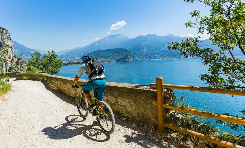
This route will accompany you as you admire the wonderful Strada della Forra (Road of the Gorge), immersed in an environment that is truly one of a kind. The gentle gradients make it accessible to many cycling enthusiasts.

This tour goes along the famous Strada della Forra, defined by Winston Churchill as the eighth wonder of the world. It starts along the Gardesana Occidentale road, just past the town of Limone sul Garda. The road, built in 1913 to link the lake to Tremosine, is very narrow and full of tunnels. In the first part, it is openly exposed high above the lake, and offers a fantastic panorama. Further on, it runs into a narrow gorge (called Forra), eroded by the Brasa river. About ten years ago it was chosen as one of the locations of a James Bond film.

The Strada della Forra does not feature any prohibitive gradients, making it a feasible option for many cyclists. About 950 metres from the beginning of the street, we recommend taking the old, abandoned road on the right, to avoid a very narrow, dark tunnel.


Further information and useful links

For more information on routes and bike services: rentals, workshops, shops and cycling friendly accommodation - APT Garda Trentino  Tel. +39 0464 554444 

Route info
Intermediate
Route number
Distance
43,3 km
Duration
2 h 30 min
Altitude difference (+)
863 m
Altitude difference (-)
863 m
Technical skills
Physical effort
Scenary
Highest point
565 m
Lowest point
64 m
Suggestions

This affords a unique view so don’t forget your camera! A high-visibility jacket and lights are essential, to ensure you are easy to see in the many tunnels along the route

Safety guidelines
  1. Give your bike a regular checkup, especially if you've had it for years.
  2. Be seen: you must wear a high vis jacket (or sash) in tunnels and on country roads after sunset.
  3. Always wear your helmet.
  4. Make sure your front and rear lights are working.
  5. Put out your arm to give advance warning of your intention to change position and before you do anything, check there are no vehicles coming up behind you.
  6. Don't use headphones or your mobile phone handsfree kit: you need all your concentration on the road!
  7. Obey the road signs: stop at traffic lights and don't ride on the wrong side of the road.
  8. If you are cycling in a group, always go in single file.
  9. You've got a bell: use it to let pedestrians know you're there. Don't ride on footpaths. If you have to then get off and push your bike.
  10. If there are cycle paths use them. It's your safety that's at stake and the rules of the road say you must
Punto di partenza
Riva del Garda - Info office
Directions

The route departs from the Riva del Garda information office in Largo Medaglie d'Oro. From here, follow the signs for Limone sul Garda, taking the Gardesana Occidentale, the very panoramic road that runs along the western shore of Lake Garda. In the summer, this road is very busy so remember to ride in single file, being careful of the vehicles that catch you up. 

There are many tunnels, in which wearing a high-vis jacket (or braces) and front and rear lights are compulsory to ensure better visibility.

Pedalling carefully, we arrive in Limone sul Garda, a stunning lakeside town. About 4 kilometres after Limone, on the right, there is a crossroads where the Strada della Forra begins. And this is also where the ascent that leads into the town of Tremosine and its areas begins. We pass through a small tunnel, then ride up the side of the mountain, before tackling a bend on the right, in a tunnel with openings that allow the light to flood in. Another 200 metres further on and we encounter another tunnel, this time longer and much darker. Before it starts, the old, abandoned road can be found on the right, and we turn onto it. Along this route we are treated to a truly unique, breathtaking panorama of Benaco below.

We return on the Provinciale 38, in a very beautiful, striking setting: here, the sight of the tiny space between the two walls of the gorge makes the hair on the back of our necks stand up. In Pieve di Tremosine, at the roundabout, we turn right and continue climbing, following the road signs for Vesio. After Vesio, we run into the small district of Fucine, where a beautiful, fun-to-ride descent begins, to be completed with care. We pass through a number of characteristic villages, such as Voltino, Ustecchio and Bassanega. Riding down through the olive groves, we again reach Limone sul Garda.

We take the SS45bis again, to return to Riva del Garda.

public transportation

The towns in Garda Trentino - Riva del Garda, Torbole sul Garda and Arco – are connected by several urban and intercity bus lines which will take you to the starting point or in the immediate surroundings.

For up-to-the-minute information on timetables and routes

You can also get to Riva del Garda and Torbole sul Garda by the public ferry service.

How to get there

Getting to northern lake Garda / Garda Trentino


Where to park

Free parking in Riva del Garda at the old hospital (via Rosmini) and the old cemetery (Viale D. Chiesa).

Pay parking at the Public Gardens Porta Orientale, Roman Baths, Viale Lutti (Ex Agraria), Monte Oro,  shopping center Blue Garden.

Riding your bike requires specific clothing and equipment, even for relatively short and easy trips. It is always better to be prepared… e.g. for bad weather or a drop your energy levels. The unexpected things also make up a part of the fun!

Do not compare a road bike with a mountain bike. They are very different, especially in technical terms, and facing a hill with a road bike could be much more difficult than facing the same hill with a MTB. Therefore, remember to throughly evaluate the type of route you plan to do and the locations you plan to cross. Do not forget to consider the current season. Has it been raining? Attention: the paint of the crosswalk could be very slick.

What do I need to bring on my bike tour?

  • Bike helmet
  • Bike gloves
  • Bike glasses
  • Waterproof/Windproof jacket
  • Headlights and rearlights
  • Reflecting suspenders
  • Plenty of snacks (for example, dried fruit or energy bars)
  • Water Bottle
  • Bike repair kit (tire levers, mini bike pump, bike tube)

It is always advised to let someone know where you plan to go and how long you expect to be.

Emergency telephone number 112.

Riva del Garda
E-Bike Stop Info Point Riva del Garda
bike stop
Torbole sul Garda - Nago
Carpentari Cycling Stories
open
closed
services
Riva del Garda
Energiabike
open
closed
bike shop
Torbole sul Garda - Nago
Garda Bike Shuttle
always open
services
Arco
Moser Sport Arco
open
closed
bike shop
You might be interested in
Discover related tours
The tough climb to Padaro | © Archivio Garda Trentino (ph. Marco Giacomello), Garda Trentino
Intermediate
Arco, Dro & Drena, Riva del Garda
San Giovanni al Monte
Distance 32,4 km
Duration 2 h 30 min
Altitude difference (+) 1.000 m
Altitude difference (-) 1.000 m
Status
open
Malga Campo | © APT Garda Trentino (ph. Matteo ISchia) , Garda Trentino
Difficult
Riva del Garda, Dro & Drena, Arco
Drena - Malga Campo
Distance 54,0 km
Duration 5 h 00 min
Altitude difference (+) 1.328 m
Altitude difference (-) 1.328 m
Status
open
The Fies hydroelectric plant | © Archivio APT Garda Trentino (ph. J. Doohan), Garda Trentino
Easy
Riva del Garda, Valle dei Laghi, Arco, Dro & Drena
Tour del Lago di Cavedine
Distance 40,0 km
Duration 2 h 20 min
Altitude difference (+) 269 m
Altitude difference (-) 269 m
Status
open
Tenno | © Archivio Garda Trentino (ph. Promovideo), Garda Trentino
Intermediate
Riva del Garda, Tenno
Tour del Lago di Tenno
Distance 22,0 km
Duration 1 h 45 min
Altitude difference (+) 567 m
Altitude difference (-) 567 m
Status
open
Lake Tenno from above | © APT Garda Trentino, North Lake Garda Trentino
Intermediate
Arco, Comano, Dro & Drena, Riva del Garda, Tenno, Valle dei Laghi
Ballino - Durone - Stenico
Distance 87,6 km
Duration 5 h 00 min
Altitude difference (+) 1.470 m
Altitude difference (-) 1.470 m
Status
open
© Roberto Vuilleumier, Garda Trentino
Intermediate
Ledro
Tour della Valle di Ledro
Distance 42,4 km
Duration 3 h 30 min
Altitude difference (+) 715 m
Altitude difference (-) 715 m
Status
closed