Hike through the woods which cover the eastern slopes of the Sarca Valley from Bosco Caproni to the little hamlet of Braila, home of the schoolmistress for whom this trail is named
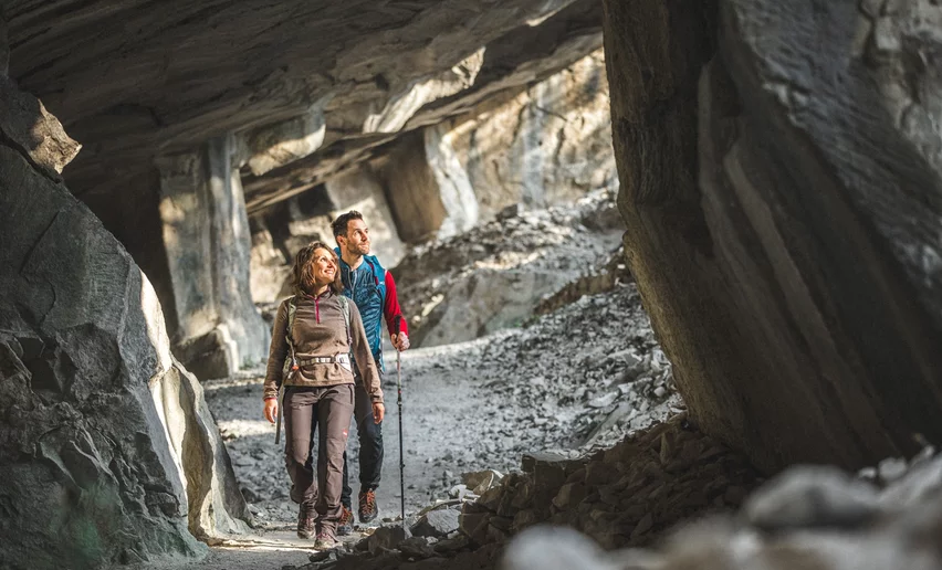
The trail winds among olive groves before it comes to what look like mysterious cave mouths on the mountainside, the oolite quarries of Bosco Caproni. Continue on through the woods along the Varino ridge which rises above the River Sarca with spectacular views of the valley. On the way back you pass through terraced vineyards which follow the course of the river. In a single trail the hiker can enjoy all the variety that Garda Trentino has to offer.


For more information on routes, services (guides, mountain huts, shops etc.) and hiking friendly accommodation: Garda Trentino - +39 0464 554444
Safety Tips
This information is subject to inevitable variations, so none of these indications are absolute. It is not entirely possible to avoid giving inexact or imprecise information, given how quickly environmental and weather conditions can change. For this reason, we decline any responsibility for changes which the user may encounter. In any case, it is advisable to check environment and weather conditions before setting out.
Caution! This trail SAT 667 is classified EE and only recommended for experienced hikers. In fact there is a short exposed stretch fitted with a steel cable by way of a handrail.
From the car park in the Moletta district of Arco take the trail SAT 667 which runs past the oolite quarries in Bosco Caproni. After the hamlet of Case Caproni turn right into the woods and continue on to the left until you come to the road leading from Massone up to to Braila. Walk along the road for about a kilometre until you rejoin the trail which leads up to the left towards Dosso Grande: here the going is quite tough and goes uphill over rock. The trail then turns downhill towards the valley: first it crosses the road again near Braila, then it goes back into the woods and there is a stretch with a walkway made of wooden slats under foot and a steel cable to hold onto where great care must be taken, especially in rainy weather. At the end of the downhill stretch take the Coste di Varim trail, following directions for the Anello Garda-Sarca (Garda-Sarca Loop) until you get back to where you started from.
This hike is a loop which can be done in either direction.
The main towns in Garda Trentino - Riva del Garda, Arco, Torbole sul Garda, Nago – are connected by several urban and intercity bus lines which will take you to the starting point of tours or in the immediate surroundings. The nearest stop to the route is "San Martino di Arco", served by the bus line B205 (Riva-Arco-Dro-Sarche-Vezzano-Trento).
You can also get to Riva del Garda and Torbole sul Garda by the public ferry service.
Up-to-date information on timetables and routes.
Moletta is on the main road statale 45 bis which goes from Arco in the direction of Trento. You can also start the hike from San Martino which is also on the main road statale 45 bis by heading northwards to the right at the junction.
Free parking in Via San Martino, left side on the main road.
You need to wear the right clothing and take the proper gear when you go hiking in the mountains. Even on relatively short easy outings make sure to take all you need so you don't run into trouble if things take an unexpected turn, for example a storm blows up or you have a sudden drop in energy levels.
What should you take when you go on a hike?
Your rucksack (for a day trip a 25/30L capacity should do) should contain:
Make sure you're wearing the right footwear for the trail and season. The going can get rough and rocky underfoot and a pair of hiking boots will protect you from sprains. When wet, a grassy slope, rocky slab or steep trail can be dangerous unless you are wearing the proper footwear.
And finally... don't forget to bring your camera! You'll need it to capture the stunning views you come across all over Garda Trentino. And if you like, you can share your memories with us at #GardaTrentino.
Emergency telephone number 112.


, Garda Trentino")

, Garda Trentino")