Logo Garda
Top

GardaTrek - Top Loop 2: descent to Lake Tenno

Riva del Garda, Tenno
Category
Difficulty
Difficult
Duration
5:00
Duration in hours
Distance
11.6
Distance in km
Status
closed
Suggested period
Jan
Feb
Mar
Apr
May
Jun
Jul
Aug
Sep
Oct
Nov
Dec

This stage goes from a hut to the next, from Nino Pernici to San Pietro, touching the verdant shores of lake Tenno and the evocative medieval village of Canale di Tenno. 

This stretch of the route is mostly downhill: it winds by the bottom part of the rocky rampart of Monte Tofino to reach Tenno's valley floor, a viewpoint onto the Alto Garda, well known for its medieval hamlets. It rises on the hillside of Monte Misone as up as San Pietro'mountain hut, a breathtaking observation post. 

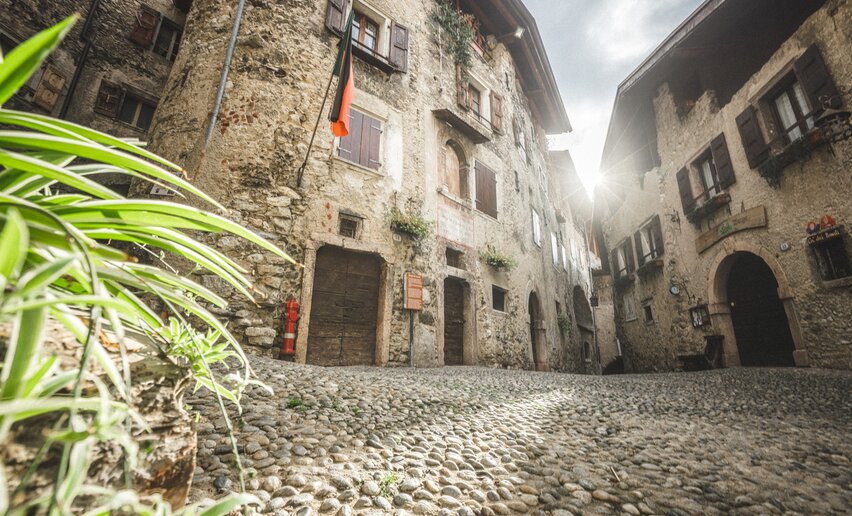
Less challenging than the previous one, this lengthily excursion still needs great effort nonetheless with great rewards. In fact, along the trail it is possible to admire the stunning intense shade of lake Tenno and visit the medieval village of Canale di Tenno, recognized from the association "Borghi più belli d'Italia" as one of the most beautiful villages in Italy. Countless are the places to freshen up if tired.

Leaving Canale in about one hour following an old mule track trough woods and chestnut grove, you reach the San Pietromoutain hut, the last stop and a natural scenic place with a magnificent overview of lake Garda.

Attention: check the condition of the trail with the manager of the mountain hut Rifugio Nino Pernici. Otherwise use the alternative route.

Further information and useful links
  • For those who would rather head back before the San Pietro hut: At the car park at lake Tenno, just opposite to the end of  trail SAT 445 coming down from Monte Vender, there's a bus stop. N.B.: buses to Riva del Garda do not pass very often. Get info about bus times on: www.gardatrentino.it
  • You can also walk down to Riva del Garda. At the parking place take the small road behind the info point (open during the summer) and follow it till a big wooden cross. Leave the cross on your left and walk down to Ville del Monte. Cross the main road and at the church take the old dirt track as far as Tenno. At the end of the track, cross the main road and go through the town. SAT 401 comes out right opposite the hotel Albergo Ristorante Antica Croce and a few steps lead down to the main road in the Gavazzo district. Watch out for traffic and follow the main road until you come to the restaurant Ristorante Foci "Da Rita", where you can catch a bus for Riva del Garda. Otherwise, you can keep going on foot towards Varone and follow the cycle path to Riva del Garda.
  • For those who would like to stay overnight in the San Pietro hut and then head back: follow signposts from the hut for the trail SAT 401. Once you get to Gavazzo you can take the bus to Riva del Garda or keep going on foot (see above).

For more information on routes, services (guides, mountain huts, shops etc.) and hiking friendly accommodation: Garda Trentino - +39 0464 554444


Route info
Difficult
Route number
Distance
11,6 km
Duration
5 h 00 min
Altitude difference (+)
678 m
Altitude difference (-)
1.305 m
Technical skills
Physical effort
Scenary
Highest point
1.715 m
Lowest point
575 m
Suggestions

In summer you should stop off at Lake Tenno. Take time out for a refreshing swim in the famous turquoise waters of the lake! 

San Pietro hut is easily accessible and one of the most popular destinations with visitors and locals alike. The hut was built on the foundations of the ancient hermitage which stood beside the little medieval chapel which is still standing today. There is a spectacular view from the terrace over Northern Garda.

Safety guidelines

While not involving any particular technical difficulties, this trek should only be undertaken by hikers with a good level of fitness and plenty of experience since there are some very exposed stretches which require due caution. The trail Sentiero della Regina from the Pernici hut to Monte Vender is often prone to avalanches during the winter season and in such cases is impassable until the debris is cleared.
You'd better check the condition of the trail with the manager of the mountain hut Rifugio Nino Pernici or contact the SAT club in Riva del Garda when you are planning the excursion. Be prepared if needs be to descend to Campi along SAT 402 (see the alternative route) where you can follow directions for Garda Trek - Medium Loop to take you to Canale di Tenno and from there to the Rifugio San Pietro hut.

From late autumn to the end of spring you can come across icy stretches which make the going treacherous unless you have the proper equipment. In any case, avoid this stretch in case of bad weather due to the risk of landslides or rockfalls in the gulleys along the way. Be sure to wear footwear and clothing suited to hiking in alpine conditions.  This trail is only recommended from June to mid-October


Safety Tips

  1. Choose itineraries that suit your physical and technical abilities. Collect information about the area you are visiting and the trail’s conditions and get a detailed trekking map.
  2. Wear clothes and take equipment that suit the difficulty and length of your tour. Keep emergency gear in your rucksack, including first aid supplies.
  3. Do not go walking alone in the mountains. In any case, tell someone where you are going and report back on returning.
  4. Look at the weather forecast before setting off and always keep an eye on the weather.
  5. In case of doubt, go back. It is better to give up than risk bad weather or face difficulties beyond your strength, ability and equipment.
  6. Do not leave marked paths and do not take shortcuts.
  7. All described walks are in a natural environment and therefore their use is at your own risk.

This information is subject to inevitable variations, so none of these indications are absolute. It is not entirely possible to avoid giving inexact or imprecise information, given how quickly environmental and weather conditions can change. For this reason, we decline any responsibility for changes which the user may encounter. In any case, it is advisable to check environment and weather conditions before setting out.

Punto di partenza
Mountain hut Nino Pernici - Bocca di Trat
Directions

From Rifugio Nino Pernici you head for Bocca Trat where you turn onto Sat 445. The track called  “Sentiero della Regina” (the Queen's Way) cuts across the eastern slopes of Monte Tofino. The trail is quite exposed, winding up and down with few flat stretches. From Monte Vender take the trail SAT 445 down to Lake Tenno. Follow the lake shore, taking the trail on the right, then head uphill past the kiosk bar until you come to the medieval village of Canale di Tenno. On the other side of the village follow signposts for SAT 406 which leads to the Rifugio San Pietro hut where you have fabulous views of Lake Garda.

public transportation

No public transport available for this tour.

How to get there

How to get to Rifugio Nino Pernici:

  • from Lenzumo at 796 m a.s.l. in Val Concei, by road for 7 km as far as the Trat pasture 1556 m, trail number 403, then along the trail for 20 minutes; on foot 2 h 15;
  • from Riva del Garda 73 m, trail number 402, passing through Santa Maria Maddalena 252 m, San Giovanni 440 m, Pinza, Campi 672 m, Rifugio Grass hut 1055 m, Dosso dei Fiori pasture 1355 m, Bocca di Trat 1581 m -  4h 15min (1h 30min from Grassi hut, which you can reach by 14 km of road)

Find out how to reach Garda Trentino

Where to park

The nearest available car park is located near Malga Grassi in Località San Martino.

You need to wear the right clothing and take the proper gear when you go hiking in the mountains. Even on relatively short easy outings make sure to take all you need so you don't run into trouble if things take an unexpected turn, for example a storm blows up or you have a sudden drop in energy levels.

What should you take when you go on a hike?

Your rucksack (for a day trip a 25/30L capacity should do) should contain:

  • water canteen (1L)
  • snacks (e.g. mixed dried fruit or chocolate)
  • First aid kit
  • windproof jacket
  • fleece
  • change of t-shirt and socks (in a plastic bag)
  • make sure to wear or at least bring a pair of long trousers
  • hat
  • sun screen
  • sunglasses
  • gloves
  • whistle to attract attention in an emergency


Make sure you're wearing the right footwear for the trail and season. The going can get rough and rocky underfoot and a pair of hiking boots will protect you from sprains. When wet, a grassy slope, rocky slab or steep trail can be dangerous unless you are wearing the proper footwear.

And finally... don't forget to bring your camera! You'll need it to capture the stunning views you come across all over Garda Trentino. And if you like, you can share your memories with us at #GardaTrentino.

Emergency telephone number 112.

Tenno
Info Point Tenno
Temporary closed
info point
Canale di Tenno - Lake Garda
Tenno
Canale di Tenno
hamlet
Arco
Free Alp - Mountain Guide Service
open
closed
climbing guide
Arco
Arco Mountain Guide
open
closed
climbing guide
Arco
MMove into Nature
hiking guide
Riva del Garda
LOLgarda
open
closed
hiking guide
Ledro
Trentino Climb
open
closed
climbing guide
Arco
Mountime - Outdoor Adventures
open
closed
climbing guide
Torbole sul Garda - Nago
Canyon Adventures
open
closed
canyoning
You might be interested in
Discover related tours
On the trail around Cima Giochello | © G.P. Calzà ©APT Garda Trentino , Garda Trentino
Difficult
Riva del Garda, Ledro
Garda Trek - Top Loop 1: from Riva del Garda to Rifugio Pernici
Distance 13,7 km
Duration 7 h 00 min
Altitude difference (+) 1.822 m
Altitude difference (-) 317 m
Status
open
San Lorenzo Church - Tenno | © Archivio Garda Trentino (ph. Watchsome), Garda Trentino
Intermediate
Tenno, Arco, Riva del Garda
Sentiero Frassati - Leg 1
Distance 6,5 km
Duration 3 h 20 min
Altitude difference (+) 886 m
Altitude difference (-) 0 m
Status
open
On the top of Monte Stivo | © G.P. Calzà ©APT Garda Trentino , Garda Trentino
Difficult
Dro & Drena, Arco
GardaTrek - Top Loop 4: to the balcony over Lake Garda
Distance 16,3 km
Duration 7 h 50 min
Altitude difference (+) 1.917 m
Altitude difference (-) 16 m
Status
open
Lake Toblino | © Armin Huber, Garda Trentino
Difficult
Valle dei Laghi, Comano
Cammino San Vili - low itinerary
Distance 107,6 km
Duration 35 h 00 min
Altitude difference (+) 3.228 m
Altitude difference (-) 4.553 m
Status
open
View of Malga Grassi | © Alessandro de Guelmi, Garda Trentino
Intermediate
Riva del Garda, Tenno
GardaTrek - TopLoop 2: descent to Lake Tenno (Alternative route)
Distance 12,1 km
Duration 4 h 30 min
Altitude difference (+) 562 m
Altitude difference (-) 1.185 m
Status
open
View over Castel Stenico from BoscoArteStenico | © Archivio Garda Trentino (ph. M. Corradi), North Lake Garda Trentino
Difficult
Valle dei Laghi, Comano
Cammino di San Vili - High itinerary
Distance 92,7 km
Duration 40 h 00 min
Altitude difference (+) 4.259 m
Altitude difference (-) 5.596 m
Status
open